Home LiDAR map
Free LiDAR map of England and Wales
Waystone shows the bare-earth LiDAR survey of England and Wales in a web browser, with around 850,000 recorded historic places across Britain and Ireland, the Roman road network and the Ordnance Survey's six-inch maps of 1843–1913 over the same ground. It is free, with nothing to install.
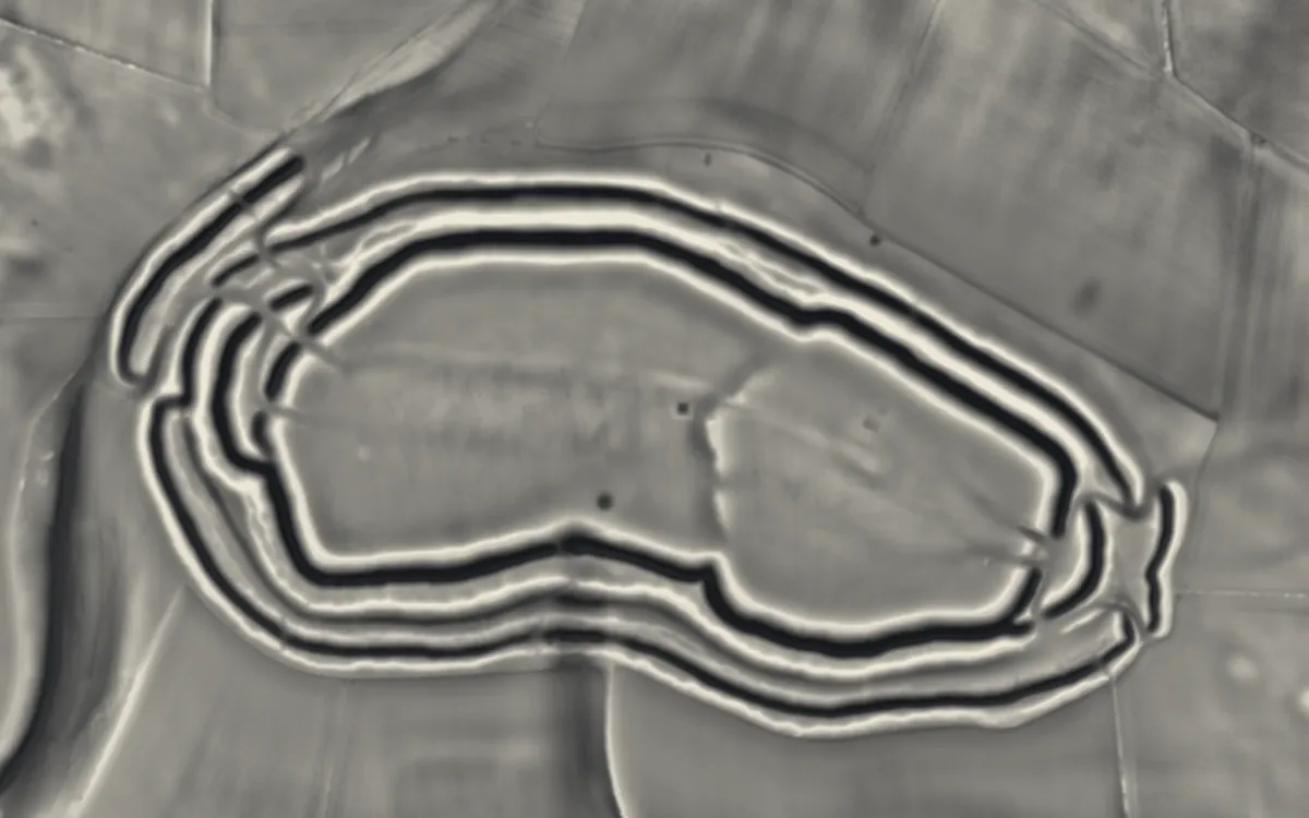
Maiden Castle on the LiDAR. Bare-earth LiDAR, drawn in your browser by the RVT toolbox (the Relief Visualization Toolbox, ZRC SAZU). It opens on Combined VAT; the panel holds all seventeen of its methods, each with its settings. LiDAR: Environment Agency, 1 m composite DTM, Open Government Licence. More about this map
The Ordnance Survey six-inch map of Maiden Castle, 1888–1913. The Ordnance Survey’s six-inch-to-the-mile map, second edition, surveyed between 1888 and 1913 and held by the National Library of Scotland, laid over today’s map with the paper colour removed, so the field boundaries, place names and antiquities the surveyors drew sit on the ground. More about this map
Roman roads near Maiden Castle. The Roman road network compiled by the Roman Roads Research Association (Digital Britannia), with each road’s grade of evidence, and the Roman forts, camps and towns along them. More about this map
Aerial archaeology at Maiden Castle. Historic England’s Aerial Archaeology Mapping: banks, ditches, enclosures and field systems traced by archaeologists from aerial photographs and LiDAR, coloured by period. The records hold 28 aerial survey features within 1 km. More about this map
See Maiden Castle with everything Waystone has
The full map lays the LiDAR under the Ordnance Survey's six-inch maps of 1843–1913, the Roman road network, Historic England's aerial survey (28 features within 1 km) and the 36 recorded places within 1 km, with search, the sun dial, the ground probe and the cross-section tool, for all of England and Wales. Free, with nothing to install.
What the map shows
LiDAR (light detection and ranging) is a laser survey flown from an aircraft. The scanner records millions of points on the ground and on everything standing on it. The points are then classified and only those on the ground surface are kept, which gives a digital terrain model (DTM): the shape of the ground with trees, crops and buildings removed.
The surveys were flown for the Environment Agency in England and for Natural Resources Wales and the Welsh Government in Wales, and are published under the Open Government Licence at one metre per pixel. On that model, earthworks show as height: the ramparts of a hillfort, a round barrow, the bank of a Roman road, the house platforms of a deserted village, or medieval ridge and furrow under a modern field.
The readings in the app
Most LiDAR viewers show one fixed hillshade image. Waystone loads the heights themselves and draws the picture in your browser with the RVT toolbox: the seventeen methods of the Relief Visualization Toolbox (ZRC SAZU), each with its own settings, starting at the toolbox's published defaults. The map opens on Combined VAT. Among the others:
- Hillshade, from one sun or from three directions. You choose the direction and height of the light, because a bank that runs towards the light casts no shadow.
- Simple and multi-scale local relief models: the broad shape of the hill is subtracted, so only the smaller features remain: banks, ditches, lynchets.
- Sky-view factor and openness: how much of the sky each point can see, which picks out ditches and hollows whatever the light.
- VAT and Combined VAT: the Visualisation for Archaeological Topography, which blends hillshading, slope, openness and sky-view factor into one picture.
- Local dominance, sky illumination, prismatic openness and the MSTP family, for when one reading hides what another shows.
- LiDAR over satellite: the relief laid over the photograph, so you can see which features are modern (a hedge, a track) and which are earthworks.
The guides explain each reading: how to read a LiDAR map, hillshade, SLRM, sky-view factor and VAT explained and what archaeology looks like on LiDAR.
What else is on the map
- Around 850,000 recorded places from the national heritage records: Historic England, Cadw, Coflein, Historic Environment Scotland, the National Monuments Service of Ireland and others.
- The Roman road network compiled by the Roman Roads Research Association, with each road's grade of evidence.
- The Ordnance Survey six-inch maps, first and second editions, surveyed 1843–1913, from the National Library of Scotland.
- Historic England's aerial archaeology mapping.
LiDAR maps by area
- LiDAR map of England264,782 recorded places
- LiDAR map of Wales59,570 recorded places
Counties and unitary areas
- Bedfordshire2,758 recorded places
- Berkshire2,929 recorded places
- Blaenau Gwent513 recorded places
- Bridgend1,278 recorded places
- Bristol969 recorded places
- Buckinghamshire3,368 recorded places
- Caerphilly1,298 recorded places
- Cambridgeshire5,057 recorded places
- Cardiff1,009 recorded places
- Carmarthenshire3,811 recorded places
- Ceredigion4,524 recorded places
- Cheshire4,033 recorded places
- City of London306 recorded places
- Conwy3,041 recorded places
- Cornwall12,534 recorded places
- County Durham3,383 recorded places
- Cumbria8,091 recorded places
- Denbighshire2,082 recorded places
- Derbyshire4,364 recorded places
- Devon15,525 recorded places
- Dorset9,756 recorded places
- East Riding of Yorkshire4,468 recorded places
- East Sussex4,469 recorded places
- Essex5,657 recorded places
- Flintshire1,458 recorded places
- Gloucestershire9,919 recorded places
- Greater London11,020 recorded places
- Greater Manchester3,495 recorded places
- Gwynedd9,941 recorded places
- Hampshire10,586 recorded places
- Herefordshire2,631 recorded places
- Hertfordshire3,487 recorded places
- Isle of Anglesey1,713 recorded places
- Isle of Wight1,510 recorded places
- Kent10,200 recorded places
- Lancashire4,138 recorded places
- Leicestershire2,659 recorded places
- Lincolnshire6,508 recorded places
- Merseyside2,543 recorded places
- Merthyr Tydfil1,481 recorded places
- Monmouthshire2,096 recorded places
- Neath Port Talbot1,259 recorded places
- Newport727 recorded places
- Norfolk12,279 recorded places
- North Yorkshire12,916 recorded places
- Northamptonshire3,550 recorded places
- Northumberland6,656 recorded places
- Nottinghamshire2,947 recorded places
- Oxfordshire5,829 recorded places
- Pembrokeshire3,398 recorded places
- Powys12,612 recorded places
- Rhondda Cynon Taf2,062 recorded places
- Rutland561 recorded places
- Shropshire3,998 recorded places
- Somerset10,717 recorded places
- South Yorkshire2,640 recorded places
- Staffordshire4,252 recorded places
- Suffolk8,198 recorded places
- Surrey3,703 recorded places
- Swansea1,470 recorded places
- Torfaen960 recorded places
- Tyne & Wear2,645 recorded places
- Vale of Glamorgan1,132 recorded places
- Warwickshire2,927 recorded places
- West Midlands2,764 recorded places
- West Sussex4,560 recorded places
- West Yorkshire5,347 recorded places
- Wiltshire9,010 recorded places
- Worcestershire2,920 recorded places
- Wrexham1,705 recorded places
Places to start
- Maiden CastleHillfort, Cheshire
- Maiden CastleHillfort, County Durham
- Hardknott Roman FortRoman fort, Cumbria
- Castell Dinas BrânCastle, Denbighshire
- Cadbury CastleHillfort, Devon
- GrimspoundSettlement, Devon
- Badbury RingsHillfort, Dorset
- Hambledon HillHillfort, Dorset
- Maiden CastleHillfort, Dorset
- Tre'r CeiriHillfort, Gwynedd
- Old Winchester HillHillfort, Hampshire
- Maiden CastleHillfort, North Yorkshire
- Wharram PercyDeserted village, North Yorkshire
- Uffington CastleHillfort, Oxfordshire
- Uffington White HorseScheduled monument, Oxfordshire
- Castell HenllysHillfort, Pembrokeshire
- Caer CaradocHillfort, Shropshire
- Old OswestryHillfort, Shropshire
- Cadbury CastleHillfort, Somerset
- Kenilworth CastleCastle, Warwickshire
- AveburyHenge, Wiltshire
- Barbury CastleHillfort, Wiltshire
- Figsbury RingHillfort, Wiltshire
- Liddington CastleHillfort, Wiltshire
- Silbury HillMound, Wiltshire
- StonehengeHenge, Wiltshire
- West Kennet Long BarrowBarrow, Wiltshire
Questions
Is there a free LiDAR map of the UK?
Yes. Waystone shows the 1 m bare-earth LiDAR of all of England and Wales free in a web browser, drawn live by the RVT toolbox, with nothing to install or download. Search a place or a postcode, or open the map and zoom in anywhere.
Is the Waystone LiDAR map free?
Yes. The web app is free to use in a browser, with nothing to install.
Which areas does the LiDAR cover?
England and Wales. The recorded historic places and the old Ordnance Survey maps cover Britain and Ireland, but there is no bare-earth LiDAR in Waystone outside England and Wales.
What resolution is the LiDAR?
The source surveys are gridded at one metre per pixel.
Does it work on a phone?
Yes. Every place and parish page works on a phone, and its live LiDAR view runs Waystone’s renderer on the phone. The full map, with every layer and tool, is built for a laptop or desktop browser.
Can I download the LiDAR data?
Waystone shows the data; it does not redistribute the files. The source data for England can be downloaded from the Defra Survey Data Download service, and for Wales from DataMap Wales, both under the Open Government Licence.
Does LiDAR show archaeology?
It shows the shape of the ground, which includes earthworks such as ramparts, barrows, banks, ditches, hollow ways and old field systems. It does not date a feature or say what it is: that needs the heritage record, old maps and, in the end, fieldwork.
Sources
- Environment Agency, National LIDAR Programme and LIDAR Composite DTM (1 m), Open Government Licence. © Environment Agency copyright and/or database right.
- Natural Resources Wales and Welsh Government LiDAR (1 m), Open Government Licence. Contains Natural Resources Wales information © Natural Resources Wales and Database Right.
- Historic England (2018). Using Airborne Lidar in Archaeological Survey: The Light Fantastic. Swindon: Historic England.
- Hesse, R. (2010). LiDAR-derived Local Relief Models: a new tool for archaeological prospection. Archaeological Prospection 17(2), 67–72.
- Zakšek, K., Oštir, K. and Kokalj, Ž. (2011). Sky-View Factor as a relief visualization technique. Remote Sensing 3(2), 398–415.
- Kokalj, Ž. and Somrak, M. (2019). Why not a single image? Combining visualizations to facilitate fieldwork and on-screen mapping. Remote Sensing 11(7), 747.
Last updated 2026-10-16.