Home LiDAR map England Somerset
LiDAR map of Somerset
Waystone shows the bare-earth LiDAR of Somerset at one metre per pixel, with the 10,717 recorded historic places the heritage records hold here, the Roman roads and the Ordnance Survey six-inch maps of 1843–1913 over the same ground. Free, in a browser.
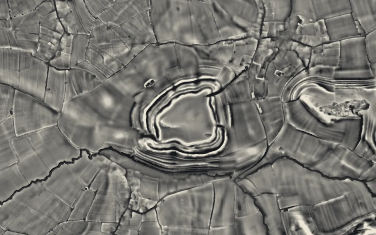
Places on the LiDAR in Somerset
Each page shows the site on the LiDAR with its record, its location and the recorded places around it.
- Alderman's Barrow at N of Almsworthy CommonBarrow
- Ballands CastleCastle
- Balt Moor WallScheduled monument
- Banwell CampHillfort
- Barle BridgeBridge
- Barlynch PrioryPriory
- Bat's CastleHillfort
- Berry CastleHillfort
- Bishop's Barn, WellsScheduled monument
- Black Ball CampHillfort
- Blacker's HillHillfort
- Bow BridgeBridge
- Bradford BridgeBridge
- Brent Knoll CampHillfort
- Brewer's CastleHillfort
- Brown's Gatehouse, WellsScheduled monument
- Burledge HillHillfort
- Burrington CampHillfort
- Burrow MumpMotte and bailey
- Bury BridgeBridge
- Bury CastleHillfort
- Cadbury CampHillfort
- Cadbury CastleHillfort
- Cannington CampHillfort
- Caratacus StoneScheduled monument
- Cary CastleMotte and bailey
- Castle NerocheMotte and bailey
- Castles CampHillfort
- Chandos Glass Cone, at the junction of Northgate and Valetta PlaceScheduled monument
- Chapel E of Adscombe FarmChapel or church
- Charterhouse CampHillfort
- Clatworthy CampHillfort
- Cleeve AbbeyAbbey
- Cleeve Toot CampHillfort
- Cockroad Wood CastleMotte and bailey
- ConygarHillfort
- Cow CastleHillfort
- Creech HillHillfort
- Culbone StoneScheduled monument
- Culverhay CastleMotte and bailey
- Curdon Wood CampHillfort
- Daw's CastleHillfort
- Dinies CampHillfort
- Dolebury WarrenHillfort
- Dovecot at Blackford FarmScheduled monument
- Down End CastleMotte and bailey
- DowsboroughHillfort
- Drove Cottage HengeHenge
- Dundon Hill HillfortHillfort
- Dunster Butter CrossCross
- Dunster CastleMotte and bailey
- Dunster DovecoteScheduled monument
- East MyneHillfort
- Elms CollieryIndustrial site
- Elworthy BarrowsHillfort
- Fairy TootBarrow
- Farleigh Hungerford CastleCastle
- Fenny CastleMotte and bailey
- Gallox BridgeBridge
- Glastonbury AbbeyAbbey
- Glastonbury Lake VillageScheduled monument
- Gough's CaveScheduled monument
- Grabbist HillHillfort
- Hales CastleMotte and bailey
- Ham HillHillfort
- Haselbury Old BridgeBridge
- Hinton PrioryPriory
- Kilve ChantryChapel or church
- King's CastleHillfort
- King's CastleHillfort
- Kingsdown CampHillfort
- Landacre BridgeBridge
- Little Solsbury HillHillfort
- Littleton gunpowder worksIndustrial site
- Long Wood EnclosureHillfort
- Low Ham Roman VillaRoman site
- Maes Knoll CampHillfort
- Maesbury CastleHillfort
- Market CrossCross
- Marston MoatScheduled monument
- Meare Lake VillagesSettlement
- Montacute CastleMotte and bailey
- Montacute PrioryPriory
- Mounsey CastleHillfort
- Muchelney AbbeyAbbey
- Multi-period site on Brean DownHillfort
- Nailsea GlassworksScheduled monument
- Newton St Loe CastleCastle
- Norton CampHillfort
- Nunney CastleCastle
- Oldberry CastleHillfort
- Picken's HoleScheduled monument
- Pill BridgeBridge
- Plainsfield CampHillfort
- Porlock Stone CircleStone circle
- Richmont CastleMotte and bailey
- Road CastleHillfort
- Roddenbury HillfortHillfort
- Ruborough CampHillfort
- Saltford Brass MillIndustrial site
- Shepton Mallet Market CrossCross
- Sir Bevil Grenville's MonumentScheduled monument
- Small Down KnollHillfort
- Stanton Drew stone circlesHenge
- Stantonbury CampHillfort
- Stogursey CastleCastle
- Stokeleigh CampHillfort
- Stone circle on Withypool Hill 670m ESE of Portford BridgeStone circle
- Stoney Littleton Long BarrowBarrow
- Stowey CastleMotte and bailey
- Tap's Combe CampHillfort
- Tarr StepsBridge
- Tedbury CampHillfort
- Telescopic Bridge, BridgwaterBridge
- The Hanging ChapelChapel or church
- The TribunalScheduled monument
- Tithe BarnScheduled monument
- Tithe Barn, Manor Farm, DoultingScheduled monument
- Trendle RingMilitary site
- Tunley CampHillfort
- Wadbury CampHillfort
- Wain's HillHillfort
- Westbury CampHillfort
- Whitestaunton CampHillfort
- Wimble TootBarrow
- Witham CharterhouseAbbey
- Woodspring PrioryPriory
- Worlebury CampHillfort
- Yarn Market, DunsterScheduled monument
LiDAR maps of the parishes of Somerset
One page for each of the 419 parishes, with a LiDAR picture and the recorded places inside it.
- Abbas and Templecombe12 recorded places
- Abbots Leigh12 recorded places
- Alford5 recorded places
- Aller9 recorded places
- Ansford15 recorded places
- Ash3 recorded places
- Ash Priors4 recorded places
- Ashbrittle2 recorded places
- Ashcott8 recorded places
- Ashill44 recorded places
- Ashwick20 recorded places
- Axbridge30 recorded places
- Babcary17 recorded places
- Backwell14 recorded places
- Badgworth13 recorded places
- Baltonsborough10 recorded places
- Banwell37 recorded places
- Barrington9 recorded places
- Barrow Gurney13 recorded places
- Barton St. David7 recorded places
- Barwick and Stoford18 recorded places
- Batcombe20 recorded places
- Bath and North East Somerset574 recorded places
- Bathampton31 recorded places
- Bathealton9 recorded places
- Batheaston23 recorded places
- Bathford34 recorded places
- Bawdrip9 recorded places
- Beckington25 recorded places
- Beercrocombe8 recorded places
- Berkley11 recorded places
- Berrow28 recorded places
- Bickenhall9 recorded places
- Bicknoller18 recorded places
- Binegar15 recorded places
- Bishop's Hull15 recorded places
- Bishop's Lydeard42 recorded places
- Blagdon16 recorded places
- Bleadon26 recorded places
- Bradford-on-Tone13 recorded places
- Bratton Seymour6 recorded places
- Brean37 recorded places
- Brent Knoll6 recorded places
- Brewham12 recorded places
- Bridgwater97 recorded places
- Bridgwater Without16 recorded places
- Broadway10 recorded places
- Brockley11 recorded places
- Brompton Ralph22 recorded places
- Brompton Regis80 recorded places
- Broomfield36 recorded places
- Brushford10 recorded places
- Bruton43 recorded places
- Brympton34 recorded places
- Buckland Dinham13 recorded places
- Buckland St Mary17 recorded places
- Burnham Without8 recorded places
- Burnham-on-Sea and Highbridge34 recorded places
- Burrington20 recorded places
- Burrowbridge15 recorded places
- Burtle9 recorded places
- Butcombe17 recorded places
- Butleigh19 recorded places
- Camerton14 recorded places
- Cannington30 recorded places
- Carhampton87 recorded places
- Castle Cary28 recorded places
- Catcott6 recorded places
- Chaffcombe6 recorded places
- Chapel Allerton5 recorded places
- Chard Town76 recorded places
- Charlcombe27 recorded places
- Charlton Horethorne17 recorded places
- Charlton Musgrove7 recorded places
- Cheddar91 recorded places
- Cheddon Fitzpaine27 recorded places
- Chedzoy4 recorded places
- Chelwood4 recorded places
- Chew Magna23 recorded places
- Chew Stoke44 recorded places
- Chewton Mendip69 recorded places
- Chilcompton14 recorded places
- Chillington4 recorded places
- Chilthorne Domer8 recorded places
- Chilton Cantelo14 recorded places
- Chilton Polden8 recorded places
- Chilton Trinity7 recorded places
- Chipstable11 recorded places
- Chiselborough12 recorded places
- Churchill33 recorded places
- Churchstanton53 recorded places
- Clapton-in-Gordano6 recorded places
- Clatworthy13 recorded places
- Claverton21 recorded places
- Cleeve8 recorded places
- Clevedon68 recorded places
- Closworth21 recorded places
- Clutton10 recorded places
- Coleford10 recorded places
- Combe Florey14 recorded places
- Combe Hay19 recorded places
- Combe St Nicholas33 recorded places
- Compton Bishop17 recorded places
- Compton Dando17 recorded places
- Compton Dundon17 recorded places
- Compton Martin12 recorded places
- Compton Pauncefoot15 recorded places
- Congresbury15 recorded places
- Corfe6 recorded places
- Corston9 recorded places
- Corton Denham13 recorded places
- Cossington6 recorded places
- Cotford St Luke3 recorded places
- Cothelstone25 recorded places
- Cranmore24 recorded places
- Creech St. Michael25 recorded places
- Crewkerne50 recorded places
- Cricket St. Thomas3 recorded places
- Croscombe13 recorded places
- Crowcombe27 recorded places
- Cucklington14 recorded places
- Cudworth5 recorded places
- Curland9 recorded places
- Curry Mallet6 recorded places
- Curry Rivel13 recorded places
- Cutcombe58 recorded places
- Dinnington11 recorded places
- Ditcheat20 recorded places
- Donyatt43 recorded places
- Doulting35 recorded places
- Dowlish Wake19 recorded places
- Downhead10 recorded places
- Drayton11 recorded places
- Dulverton44 recorded places
- Dundry5 recorded places
- Dunkerton and Tunley13 recorded places
- Dunster83 recorded places
- Durleigh7 recorded places
- Durston11 recorded places
- East Brent14 recorded places
- East Chinnock13 recorded places
- East Coker28 recorded places
- East Harptree12 recorded places
- East Huntspill20 recorded places
- East Pennard9 recorded places
- East Quantoxhead39 recorded places
- Edington6 recorded places
- Elworthy16 recorded places
- Emborough20 recorded places
- Englishcombe12 recorded places
- Enmore13 recorded places
- Evercreech17 recorded places
- Exford48 recorded places
- Exmoor202 recorded places
- Exton37 recorded places
- Farmborough7 recorded places
- Farrington Gurney6 recorded places
- Fiddington7 recorded places
- Fitzhead10 recorded places
- Fivehead21 recorded places
- Flax Bourton5 recorded places
- Freshford19 recorded places
- Frome80 recorded places
- Glastonbury33 recorded places
- Goathurst20 recorded places
- Godney22 recorded places
- Great Elm13 recorded places
- Greinton3 recorded places
- Halse12 recorded places
- Hambridge and Westport14 recorded places
- Hardington Mandeville14 recorded places
- Haselbury Plucknett17 recorded places
- Hatch Beauchamp18 recorded places
- Hemington21 recorded places
- Henstridge15 recorded places
- High Ham16 recorded places
- High Littleton9 recorded places
- Hinton Blewett4 recorded places
- Hinton Charterhouse58 recorded places
- Hinton St. George19 recorded places
- Holcombe9 recorded places
- Holford44 recorded places
- Holton6 recorded places
- Horsington11 recorded places
- Horton10 recorded places
- Huish Champflower16 recorded places
- Huish Episcopi13 recorded places
- Hutton40 recorded places
- Ilchester21 recorded places
- Ilminster54 recorded places
- Ilton64 recorded places
- Isle Abbotts12 recorded places
- Isle Brewers3 recorded places
- Keinton Mandeville8 recorded places
- Kelston26 recorded places
- Kenn5 recorded places
- Kewstoke41 recorded places
- Keynsham42 recorded places
- Kilmersdon28 recorded places
- Kilve12 recorded places
- Kingsbury Episcopi27 recorded places
- Kingsdon6 recorded places
- Kingston Seymour13 recorded places
- Kingston St. Mary42 recorded places
- Kingstone8 recorded places
- Kingweston7 recorded places
- Knowle St. Giles13 recorded places
- Lamyatt8 recorded places
- Langford Budville14 recorded places
- Langport24 recorded places
- Leigh-on-Mendip6 recorded places
- Litton12 recorded places
- Locking25 recorded places
- Long Ashton52 recorded places
- Long Load7 recorded places
- Long Sutton19 recorded places
- Lopen9 recorded places
- Lovington15 recorded places
- Loxton42 recorded places
- Luccombe83 recorded places
- Lullington28 recorded places
- Luxborough19 recorded places
- Lydeard St. Lawrence24 recorded places
- Lydford-on-Fosse16 recorded places
- Lympsham13 recorded places
- Lyng14 recorded places
- Maperton8 recorded places
- Mark23 recorded places
- Marksbury10 recorded places
- Marston Magna11 recorded places
- Martock75 recorded places
- Meare29 recorded places
- Mells26 recorded places
- Merriott26 recorded places
- Middlezoy22 recorded places
- Midsomer Norton20 recorded places
- Milborne Port31 recorded places
- Milton Clevedon7 recorded places
- Milverton29 recorded places
- Minehead72 recorded places
- Minehead Without53 recorded places
- Misterton5 recorded places
- Monksilver12 recorded places
- Monkton Combe18 recorded places
- Montacute44 recorded places
- Moorlinch9 recorded places
- Muchelney25 recorded places
- Mudford17 recorded places
- Nailsea19 recorded places
- Nempnett Thrubwell23 recorded places
- Nether Stowey14 recorded places
- Nettlecombe37 recorded places
- Newton St. Loe27 recorded places
- North Barrow3 recorded places
- North Cadbury17 recorded places
- North Cheriton9 recorded places
- North Curry47 recorded places
- North Perrott13 recorded places
- North Petherton75 recorded places
- North Stoke9 recorded places
- North Wootton5 recorded places
- Norton Fitzwarren21 recorded places
- Norton Malreward9 recorded places
- Norton St Philip47 recorded places
- Norton sub Hamdon19 recorded places
- Nunney12 recorded places
- Nynehead14 recorded places
- Oake15 recorded places
- Oare37 recorded places
- Odcombe13 recorded places
- Old Cleeve54 recorded places
- Orchard Portman15 recorded places
- Othery12 recorded places
- Otterford37 recorded places
- Otterhampton22 recorded places
- Over Stowey34 recorded places
- Paulton11 recorded places
- Pawlett51 recorded places
- Peasedown St. John8 recorded places
- Pen Selwood11 recorded places
- Pill and Easton-in-Gordano16 recorded places
- Pilton23 recorded places
- Pitcombe20 recorded places
- Pitminster35 recorded places
- Pitney8 recorded places
- Porlock63 recorded places
- Portbury13 recorded places
- Portishead47 recorded places
- Priddy279 recorded places
- Priston10 recorded places
- Publow18 recorded places
- Puckington7 recorded places
- Puriton15 recorded places
- Puxton4 recorded places
- Pylle6 recorded places
- Queen Camel18 recorded places
- Radstock19 recorded places
- Rimpton7 recorded places
- Rode33 recorded places
- Rodney Stoke37 recorded places
- Ruishton13 recorded places
- Saltford20 recorded places
- Sampford Arundel14 recorded places
- Sampford Brett14 recorded places
- Seavington St Mary10 recorded places
- Seavington St Michael3 recorded places
- Selwood29 recorded places
- Selworthy56 recorded places
- Shapwick17 recorded places
- Sharpham8 recorded places
- Shepton Beauchamp11 recorded places
- Shepton Mallet47 recorded places
- Shepton Montague13 recorded places
- Shipham44 recorded places
- Shoscombe17 recorded places
- Skilgate8 recorded places
- Somerton25 recorded places
- South Barrow5 recorded places
- South Cadbury and Sutton Montis14 recorded places
- South Petherton39 recorded places
- Southstoke34 recorded places
- Sparkford14 recorded places
- Spaxton41 recorded places
- St Cuthbert Out166 recorded places
- St. Catherine14 recorded places
- St. Georges1 recorded places
- Stanton Drew9 recorded places
- Staple Fitzpaine21 recorded places
- Stawell10 recorded places
- Stawley21 recorded places
- Stockland Bristol4 recorded places
- Stocklinch12 recorded places
- Stogumber56 recorded places
- Stogursey46 recorded places
- Stoke St Michael21 recorded places
- Stoke St. Gregory10 recorded places
- Stoke St. Mary10 recorded places
- Stoke Trister9 recorded places
- Stoke sub Hamdon36 recorded places
- Ston Easton20 recorded places
- Stowey-Sutton15 recorded places
- Stratton on the Fosse19 recorded places
- Street25 recorded places
- Stringston41 recorded places
- Swainswick10 recorded places
- Tatworth and Forton31 recorded places
- Taunton140 recorded places
- Tellisford18 recorded places
- Temple Cloud with Cameley9 recorded places
- The Charltons24 recorded places
- Thornfalcon13 recorded places
- Thurloxton6 recorded places
- Tickenham10 recorded places
- Timberscombe23 recorded places
- Timsbury11 recorded places
- Tintinhull24 recorded places
- Tolland9 recorded places
- Treborough16 recorded places
- Trudoxhill20 recorded places
- Trull10 recorded places
- Ubley14 recorded places
- Upton17 recorded places
- Upton Noble4 recorded places
- Walton8 recorded places
- Walton-in-Gordano17 recorded places
- Wambrook24 recorded places
- Wanstrow32 recorded places
- Watchet21 recorded places
- Wayford3 recorded places
- Weare10 recorded places
- Wedmore38 recorded places
- Wellington40 recorded places
- Wellington Without14 recorded places
- Wellow34 recorded places
- Wells88 recorded places
- Wembdon11 recorded places
- West Bagborough45 recorded places
- West Bradley15 recorded places
- West Buckland7 recorded places
- West Camel15 recorded places
- West Coker15 recorded places
- West Crewkerne9 recorded places
- West Harptree12 recorded places
- West Hatch5 recorded places
- West Huntspill16 recorded places
- West Monkton24 recorded places
- West Pennard11 recorded places
- West Quantoxhead27 recorded places
- West and Middle Chinnock26 recorded places
- Westbury35 recorded places
- Westfield11 recorded places
- Weston-in-Gordano14 recorded places
- Weston-super-Mare211 recorded places
- Westonzoyland30 recorded places
- Whatley13 recorded places
- Whitchurch5 recorded places
- Whitelackington16 recorded places
- Whitestaunton27 recorded places
- Wick St. Lawrence9 recorded places
- Williton49 recorded places
- Wincanton36 recorded places
- Winford19 recorded places
- Winscombe and Sandford31 recorded places
- Winsford58 recorded places
- Winsham29 recorded places
- Witham Friary12 recorded places
- Withycombe34 recorded places
- Withypool and Hawkridge59 recorded places
- Wiveliscombe33 recorded places
- Wookey16 recorded places
- Woolavington5 recorded places
- Wootton Courtenay33 recorded places
- Wraxall and Failand32 recorded places
- Wrington27 recorded places
- Yarlington8 recorded places
- Yatton18 recorded places
- Yeovil56 recorded places
- Yeovil Without3 recorded places
- Yeovilton and District40 recorded places
About the LiDAR
The terrain model is made from an airborne laser survey with vegetation and buildings removed, so earthworks show as height: hillfort ramparts, barrows, Roman road banks, hollow ways and ridge and furrow. In the app the picture is computed as you change the settings, with a moveable sun, a local relief model, multidirectional hillshading and the VAT composite. See how to read a LiDAR map and what archaeology looks like on LiDAR.
Sources
- LiDAR: Environment Agency, 1 m composite DTM, Open Government Licence.
- Recorded places: the national heritage records (Historic England, Cadw, Coflein and others) as held by Waystone.
Last updated 2026-10-16.