LiDAR map of Devon
Waystone shows the bare-earth LiDAR of Devon at one metre per pixel, with the 15,525 recorded historic places the heritage records hold here, the Roman roads and the Ordnance Survey six-inch maps of 1843–1913 over the same ground. Free, in a browser.
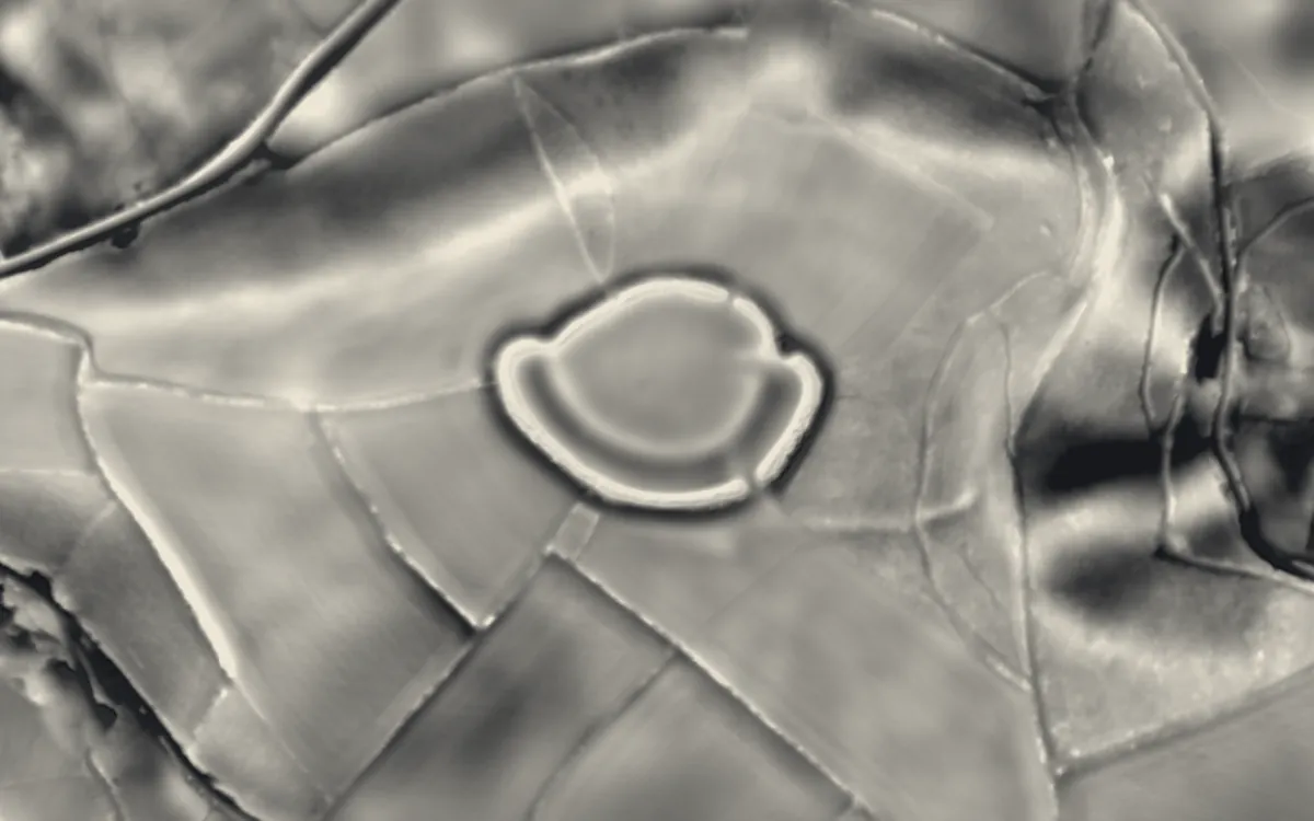
Places on the LiDAR in Devon
Each page shows the site on the LiDAR with its record, its location and the recorded places around it.
- Ash Hole CavernScheduled monument
- Axmouth Old BridgeBridge
- Bampton CastleMotte and bailey
- Barnstaple CastleMotte and bailey
- Bayard's Cove FortCastle
- Belbury CastleHillfort
- Berry CastleHillfort
- Berry Pomeroy CastleCastle
- Berry's WoodHillfort
- Bishop's Palace, PaigntonScheduled monument
- Blackbury CampHillfort
- Blackdown RingsHillfort
- Boringdon CampHillfort
- Bowden BatteryMilitary site
- Brent HillHillfort
- Brisworthy stone circleStone circle
- Brixham BatteryMilitary site
- Broadbury CastleEarthwork
- Broadsands Chambered TombScheduled monument
- Buckland AbbeyAbbey
- Cadbury CastleHillfort
- Canonsleigh AbbeyAbbey
- Castle CloseHillfort
- Castle DykeHillfort
- Clovelly DykesHillfort
- Cornworthy PrioryPriory
- Cotley CastleHillfort
- Cow CaveScheduled monument
- Cranbrook CastleHillfort
- Cranmore CastleHillfort
- Crownhill FortMilitary site
- Dartmouth CastleCastle
- Dumpdon HillHillfort
- Efford FortMilitary site
- Exeter Underground PassagesScheduled monument
- Exeter city wallsScheduled monument
- Eylesbarrow MineIndustrial site
- Fort AustinMilitary site
- Fort BovisandMilitary site
- Fort StamfordMilitary site
- Frithelstock PrioryPriory
- Gidleigh CastleCastle
- Greenway CampHillfort
- GrimspoundSettlement
- Hawkesdown HillHillfort
- Haytor Granite TramwayScheduled monument
- HemburyHillfort
- Hembury CastleHillfort
- Hembury Castle, TythecottHillfort
- Hemyock CastleCastle
- Holne Chase CastleHillfort
- Huntsham CastleHillfort
- Kents CavernScheduled monument
- Knowle Hill CastleHillfort
- Knowles BatteryMilitary site
- Laira BatteryMilitary site
- LeechwellScheduled monument
- Lundy Old LightScheduled monument
- Malmsmead BridgeBridge
- Meldon ViaductBridge
- Membury CastleHillfort
- Milber DownHillfort
- Motte with two baileys and a multivallate hillfort at Burley WoodScheduled monument
- Musbury CastleHillfort
- Newenham AbbeyAbbey
- Okehampton CastleMotte and bailey
- Old Exe BridgeBridge
- Pixie's HoleScheduled monument
- Plymouth CastleCastle
- Plympton CastleCastle
- Plympton PrioryPriory
- Polsloe PrioryPriory
- PosburyHillfort
- Prestonbury CastleHillfort
- Roborough CastleHillfort
- Rougemont CastleCastle
- Royal CitadelMilitary site
- Salcombe CastleCastle
- Sidbury CastleHillfort
- Slapton CastleHillfort
- Smythapark hillfortHillfort
- Spinsters' RockScheduled monument
- St Michael's Chapel, Chapel HillChapel or church
- St Nicholas PrioryPriory
- Stanborough CampHillfort
- Stoke HillHillfort
- Tavistock AbbeyAbbey
- Tiverton CastleCastle
- Torre AbbeyAbbey
- Totnes CastleMotte and bailey
- Totnes PrioryPriory
- Voley CastleHillfort
- Wasteberry CampHillfort
- Western Kings Artillery TowerMilitary site
- Windmill Hill CavernScheduled monument
- WoodburyHillfort
- Woodbury CastleHillfort
- Woodlands FortMilitary site
- Wooston CastleHillfort
- Yelland Stone RowsStone circle
- Yellowberries CopseMilitary site
LiDAR maps of the parishes of Devon
One page for each of the 431 parishes, with a LiDAR picture and the recorded places inside it.
- Abbots Bickington6 recorded places
- Abbotsham23 recorded places
- Abbotskerswell19 recorded places
- All Saints31 recorded places
- Alverdiscott9 recorded places
- Alwington16 recorded places
- Area not comprised in any Parish-Lundy Island47 recorded places
- Arlington19 recorded places
- Ashburton75 recorded places
- Ashcombe22 recorded places
- Ashford6 recorded places
- Ashprington34 recorded places
- Ashreigney14 recorded places
- Ashton21 recorded places
- Ashwater17 recorded places
- Atherington20 recorded places
- Aveton Gifford41 recorded places
- Awliscombe23 recorded places
- Axminster159 recorded places
- Axmouth68 recorded places
- Aylesbeare22 recorded places
- Bampton31 recorded places
- Barnstaple123 recorded places
- Beaford22 recorded places
- Beaworthy23 recorded places
- Beer21 recorded places
- Belstone23 recorded places
- Bere Ferrers54 recorded places
- Berry Pomeroy15 recorded places
- Berrynarbor59 recorded places
- Bickington20 recorded places
- Bickleigh23 recorded places
- Bickleigh89 recorded places
- Bicton22 recorded places
- Bideford77 recorded places
- Bigbury46 recorded places
- Bishop's Nympton26 recorded places
- Bishop's Tawton15 recorded places
- Bishopsteignton74 recorded places
- Bittadon12 recorded places
- Black Torrington16 recorded places
- Blackawton20 recorded places
- Bondleigh7 recorded places
- Bovey Tracey90 recorded places
- Bow32 recorded places
- Bradford12 recorded places
- Bradninch43 recorded places
- Bradstone16 recorded places
- Bradworthy22 recorded places
- Brampford Speke21 recorded places
- Branscombe50 recorded places
- Bratton Clovelly41 recorded places
- Bratton Fleming49 recorded places
- Braunton223 recorded places
- Brayford49 recorded places
- Brendon and Countisbury120 recorded places
- Brentor12 recorded places
- Bridestowe34 recorded places
- Bridford12 recorded places
- Bridgerule14 recorded places
- Brixham101 recorded places
- Brixton45 recorded places
- Broad Clyst105 recorded places
- Broadhembury44 recorded places
- Broadhempston23 recorded places
- Broadwoodkelly7 recorded places
- Broadwoodwidger27 recorded places
- Brushford7 recorded places
- Buckerell9 recorded places
- Buckfastleigh37 recorded places
- Buckland Brewer12 recorded places
- Buckland Filleigh13 recorded places
- Buckland Monachorum109 recorded places
- Buckland in the Moor14 recorded places
- Buckland-Tout-Saints16 recorded places
- Budleigh Salterton23 recorded places
- Bulkworthy5 recorded places
- Burlescombe41 recorded places
- Burrington8 recorded places
- Butterleigh4 recorded places
- Cadbury9 recorded places
- Cadeleigh9 recorded places
- Chagford70 recorded places
- Challacombe65 recorded places
- Chardstock21 recorded places
- Charleton12 recorded places
- Chawleigh30 recorded places
- Cheriton Bishop12 recorded places
- Cheriton Fitzpaine24 recorded places
- Chittlehamholt7 recorded places
- Chittlehampton24 recorded places
- Chivelstone13 recorded places
- Christow19 recorded places
- Chudleigh90 recorded places
- Chulmleigh46 recorded places
- Churchstow27 recorded places
- Clannaborough6 recorded places
- Clawton20 recorded places
- Clayhanger5 recorded places
- Clayhidon30 recorded places
- Clovelly67 recorded places
- Clyst Honiton65 recorded places
- Clyst Hydon11 recorded places
- Clyst St. George14 recorded places
- Clyst St. Lawrence13 recorded places
- Clyst St. Mary10 recorded places
- Coffinswell15 recorded places
- Colaton Raleigh19 recorded places
- Coldridge36 recorded places
- Colebrooke27 recorded places
- Colyford15 recorded places
- Colyton37 recorded places
- Combe Martin65 recorded places
- Combe Raleigh11 recorded places
- Combpyne Rousdon16 recorded places
- Cookbury2 recorded places
- Copplestone7 recorded places
- Cornwood141 recorded places
- Cornworthy13 recorded places
- Coryton10 recorded places
- Cotleigh9 recorded places
- Cranbrook6 recorded places
- Crediton42 recorded places
- Crediton Hamlets24 recorded places
- Cruwys Morchard17 recorded places
- Cullompton72 recorded places
- Culmstock22 recorded places
- Dalwood11 recorded places
- Dartington30 recorded places
- Dartmoor Forest271 recorded places
- Dartmouth82 recorded places
- Dawlish94 recorded places
- Dean Prior16 recorded places
- Denbury and Torbryan32 recorded places
- Diptford27 recorded places
- Dittisham21 recorded places
- Doddiscombsleigh14 recorded places
- Dolton14 recorded places
- Dowland4 recorded places
- Down St. Mary11 recorded places
- Drewsteignton50 recorded places
- Dunchideock17 recorded places
- Dunkeswell61 recorded places
- Dunsford26 recorded places
- Dunterton20 recorded places
- East Allington21 recorded places
- East Anstey23 recorded places
- East Budleigh38 recorded places
- East Down16 recorded places
- East Portlemouth12 recorded places
- East Putford8 recorded places
- East Worlington20 recorded places
- East and West Buckland30 recorded places
- Eggesford19 recorded places
- Ermington36 recorded places
- Exbourne5 recorded places
- Exeter348 recorded places
- Exminster71 recorded places
- Exmouth79 recorded places
- Farringdon21 recorded places
- Farway33 recorded places
- Feniton14 recorded places
- Filleigh32 recorded places
- Fremington35 recorded places
- Frithelstock6 recorded places
- Frogmore and Sherford12 recorded places
- George Nympton10 recorded places
- Georgeham47 recorded places
- Germansweek10 recorded places
- Gidleigh36 recorded places
- Gittisham26 recorded places
- Goodleigh11 recorded places
- Great Torrington44 recorded places
- Gulworthy76 recorded places
- Haccombe with Combe30 recorded places
- Halberton56 recorded places
- Halwell and Moreleigh18 recorded places
- Halwill17 recorded places
- Harberton34 recorded places
- Harford48 recorded places
- Hartland151 recorded places
- Hatherleigh23 recorded places
- Hawkchurch42 recorded places
- Heanton Punchardon22 recorded places
- Hemyock40 recorded places
- Hennock34 recorded places
- High Bickington16 recorded places
- Highampton10 recorded places
- Hittisleigh10 recorded places
- Hockworthy11 recorded places
- Holbeton37 recorded places
- Holcombe Burnell19 recorded places
- Holcombe Rogus15 recorded places
- Hollacombe3 recorded places
- Holne34 recorded places
- Holsworthy11 recorded places
- Holsworthy Hamlets6 recorded places
- Honiton37 recorded places
- Horrabridge5 recorded places
- Horwood, Lovacott and Newton Tracey18 recorded places
- Huish5 recorded places
- Huntsham9 recorded places
- Huntshaw9 recorded places
- Huxham16 recorded places
- Iddesleigh9 recorded places
- Ide33 recorded places
- Ideford40 recorded places
- Ilfracombe85 recorded places
- Ilsington59 recorded places
- Instow49 recorded places
- Inwardleigh15 recorded places
- Ipplepen29 recorded places
- Ivybridge13 recorded places
- Jacobstowe12 recorded places
- Kelly13 recorded places
- Kenn88 recorded places
- Kennerleigh1 recorded places
- Kentisbeare32 recorded places
- Kentisbury39 recorded places
- Kenton34 recorded places
- Kilmington10 recorded places
- King's Nympton28 recorded places
- Kingsbridge43 recorded places
- Kingskerswell31 recorded places
- Kingsteignton63 recorded places
- Kingston18 recorded places
- Kingswear44 recorded places
- Knowstone11 recorded places
- Lamerton36 recorded places
- Landcross3 recorded places
- Landkey11 recorded places
- Lands Common to Axminster and Kilmington C.P.s1 recorded places
- Lands common to Bridestowe and Sourton CP's31 recorded places
- Langtree6 recorded places
- Lapford20 recorded places
- Lewtrenchard25 recorded places
- Lifton25 recorded places
- Little Torrington15 recorded places
- Littleham10 recorded places
- Littlehempston12 recorded places
- Loddiswell35 recorded places
- Loxbeare10 recorded places
- Loxhore10 recorded places
- Luffincott4 recorded places
- Luppitt46 recorded places
- Lustleigh25 recorded places
- Lydford22 recorded places
- Lympstone17 recorded places
- Lynton and Lynmouth124 recorded places
- Malborough69 recorded places
- Mamhead29 recorded places
- Manaton59 recorded places
- Mariansleigh8 recorded places
- Marldon12 recorded places
- Martinhoe36 recorded places
- Marwood16 recorded places
- Mary Tavy24 recorded places
- Marystow24 recorded places
- Meavy56 recorded places
- Meeth14 recorded places
- Membury36 recorded places
- Merton13 recorded places
- Meshaw6 recorded places
- Milton Abbot63 recorded places
- Milton Damerel10 recorded places
- Modbury66 recorded places
- Molland45 recorded places
- Monkleigh13 recorded places
- Monkokehampton9 recorded places
- Monkton6 recorded places
- Morchard Bishop23 recorded places
- Morebath14 recorded places
- Moretonhampstead35 recorded places
- Mortehoe47 recorded places
- Musbury23 recorded places
- Nether Exe28 recorded places
- Newton Abbot87 recorded places
- Newton Poppleford and Harpford25 recorded places
- Newton St. Cyres54 recorded places
- Newton St. Petrock5 recorded places
- Newton and Noss48 recorded places
- North Bovey48 recorded places
- North Huish23 recorded places
- North Molton80 recorded places
- North Tawton93 recorded places
- Northam103 recorded places
- Northcott6 recorded places
- Northleigh5 recorded places
- Northlew27 recorded places
- Nymet Rowland7 recorded places
- Oakford17 recorded places
- Offwell11 recorded places
- Ogwell24 recorded places
- Okehampton22 recorded places
- Okehampton Hamlets80 recorded places
- Otterton35 recorded places
- Ottery St. Mary37 recorded places
- Pancrasweek22 recorded places
- Parkham23 recorded places
- Parracombe65 recorded places
- Payhembury23 recorded places
- Peter Tavy133 recorded places
- Peters Marland16 recorded places
- Petrockstow17 recorded places
- Pilton West5 recorded places
- Plymouth639 recorded places
- Plymtree24 recorded places
- Poltimore29 recorded places
- Poughill5 recorded places
- Powderham23 recorded places
- Puddington5 recorded places
- Pyworthy13 recorded places
- Queen's Nympton2 recorded places
- Rackenford13 recorded places
- Rattery23 recorded places
- Rewe39 recorded places
- Ringmore14 recorded places
- Roborough11 recorded places
- Rockbeare42 recorded places
- Romansleigh6 recorded places
- Rose Ash18 recorded places
- Salcombe31 recorded places
- Sampford Courtenay20 recorded places
- Sampford Peverell18 recorded places
- Sampford Spiney10 recorded places
- Sandford15 recorded places
- Satterleigh and Warkleigh21 recorded places
- Seaton20 recorded places
- Shaldon32 recorded places
- Shaugh Prior392 recorded places
- Shebbear9 recorded places
- Sheepstor72 recorded places
- Sheepwash4 recorded places
- Sheldon15 recorded places
- Shillingford St. George34 recorded places
- Shirwell10 recorded places
- Shobrooke52 recorded places
- Shute22 recorded places
- Sidmouth106 recorded places
- Silverton94 recorded places
- Slapton13 recorded places
- Sourton19 recorded places
- South Brent69 recorded places
- South Huish20 recorded places
- South Milton21 recorded places
- South Molton31 recorded places
- South Pool8 recorded places
- South Tawton86 recorded places
- Southleigh10 recorded places
- Sowton33 recorded places
- Sparkwell140 recorded places
- Spreyton19 recorded places
- St. Giles in the Wood37 recorded places
- St. Giles on the Heath15 recorded places
- Starcross24 recorded places
- Staverton33 recorded places
- Sticklepath7 recorded places
- Stockland32 recorded places
- Stockleigh English1 recorded places
- Stockleigh Pomeroy12 recorded places
- Stoke Canon18 recorded places
- Stoke Fleming13 recorded places
- Stoke Gabriel16 recorded places
- Stoke Rivers9 recorded places
- Stokeinteignhead22 recorded places
- Stokenham45 recorded places
- Stoodleigh11 recorded places
- Stowford26 recorded places
- Strete18 recorded places
- Sutcombe9 recorded places
- Swimbridge13 recorded places
- Sydenham Damerel18 recorded places
- Talaton17 recorded places
- Tavistock55 recorded places
- Tawstock24 recorded places
- Tedburn St. Mary13 recorded places
- Teigngrace38 recorded places
- Teignmouth53 recorded places
- Templeton5 recorded places
- Tetcott10 recorded places
- Thelbridge8 recorded places
- Thornbury9 recorded places
- Thorverton43 recorded places
- Throwleigh37 recorded places
- Thrushelton13 recorded places
- Thurlestone28 recorded places
- Tiverton108 recorded places
- Torbay318 recorded places
- Totnes75 recorded places
- Trentishoe25 recorded places
- Trusham8 recorded places
- Twitchen20 recorded places
- Uffculme49 recorded places
- Ugborough92 recorded places
- Uplowman30 recorded places
- Uplyme21 recorded places
- Upottery52 recorded places
- Upton Hellions6 recorded places
- Upton Pyne54 recorded places
- Virginstow4 recorded places
- Walkhampton126 recorded places
- Washfield14 recorded places
- Washford Pyne5 recorded places
- Weare Giffard11 recorded places
- Welcombe8 recorded places
- Wembury122 recorded places
- Wembworthy15 recorded places
- West Alvington18 recorded places
- West Anstey12 recorded places
- West Buckfastleigh8 recorded places
- West Down21 recorded places
- West Hill3 recorded places
- West Putford8 recorded places
- Westleigh33 recorded places
- Whimple18 recorded places
- Whitchurch26 recorded places
- Whitestone17 recorded places
- Widecombe in the Moor84 recorded places
- Widworthy27 recorded places
- Willand12 recorded places
- Winkleigh25 recorded places
- Witheridge28 recorded places
- Woodbury79 recorded places
- Woodland17 recorded places
- Woodleigh16 recorded places
- Woolfardisworthy8 recorded places
- Woolfardisworthy23 recorded places
- Yarcombe57 recorded places
- Yarnscombe13 recorded places
- Yealmpton45 recorded places
- Zeal Monachorum15 recorded places
About the LiDAR
The terrain model is made from an airborne laser survey with vegetation and buildings removed, so earthworks show as height: hillfort ramparts, barrows, Roman road banks, hollow ways and ridge and furrow. In the app the picture is computed as you change the settings, with a moveable sun, a local relief model, multidirectional hillshading and the VAT composite. See how to read a LiDAR map and what archaeology looks like on LiDAR.
Sources
- LiDAR: Environment Agency, 1 m composite DTM, Open Government Licence.
- Recorded places: the national heritage records (Historic England, Cadw, Coflein and others) as held by Waystone.
Last updated 2026-10-16.