Home LiDAR map England Derbyshire
LiDAR map of Derbyshire
Waystone shows the bare-earth LiDAR of Derbyshire at one metre per pixel, with the 4,364 recorded historic places the heritage records hold here, the Roman roads and the Ordnance Survey six-inch maps of 1843–1913 over the same ground. Free, in a browser.
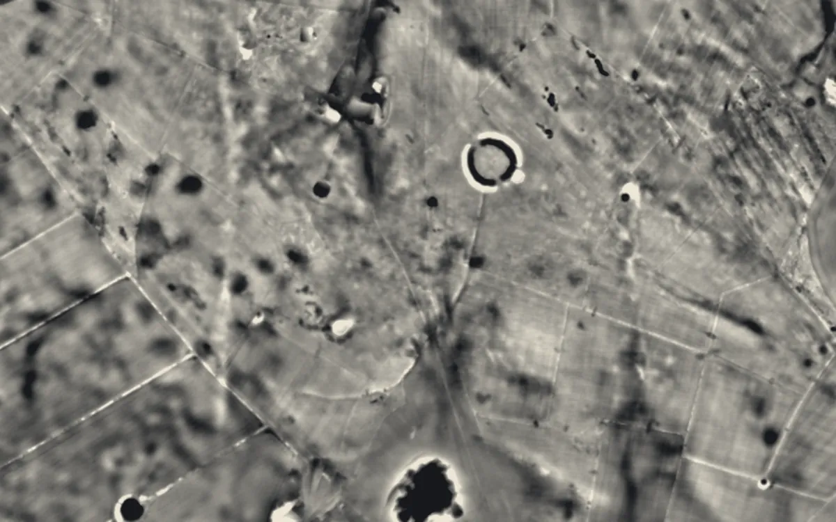
Places on the LiDAR in Derbyshire
Each page shows the site on the LiDAR with its record, its location and the recorded places around it.
- Arbor LowHenge
- ArdotaliaRoman fort
- Bakewell BridgeBridge
- Bakewell CastleMotte and bailey
- Batham GateRoman site
- Bolsover CastleCastle
- Butterley GangroadScheduled monument
- Castle GresleyMotte and bailey
- Castleton Medieval HospitalScheduled monument
- Castleton Town DefencesMilitary site
- Codnor CastleCastle
- Dale AbbeyAbbey
- Doll TorStone circle
- Embanked stone circle known as Wet Withens, and adjacent cairnStone circle
- Five WellsBarrow
- Gautries RakeIndustrial site
- Gib HillBarrow
- Heath Wood barrow cemeteryScheduled monument
- Hob Hurst's HouseBarrow
- Hordron Edge stone circleStone circle
- Horston CastleCastle
- Lismore Fields Mesolithic and Neolithic settlementScheduled monument
- Lumford MillIndustrial site
- Magpie MineIndustrial site
- Matlock BridgeBridge
- Medieval settlement, including site of chapel and part of the open field system, immediately north east of Alkmonton Old Hall FaDeserted village
- MinninglowBarrow
- Mouselow CastleMotte and bailey
- Navio Roman fortRoman fort
- Nine Stones CloseStone circle
- Odin Mine nucleated lead mine and ore works, 350m WNW of Knowlegates FarmIndustrial site
- Old Millclose engine house and associated features, 570m south west of Cowley HallScheduled monument
- Padley HallScheduled monument
- Peveril CastleCastle
- Pilsbury CastleMotte and bailey
- Pinxton CastleMotte and bailey
- Pleasley CollieryIndustrial site
- Sutton Scarsdale HallScheduled monument
- Swarkestone BridgeBridge
- The Bull RingHenge
- Tideslow Rake lead rake and lime kilnIndustrial site
- Yeaveley PreceptoryScheduled monument
LiDAR maps of the parishes of Derbyshire
One page for each of the 278 parishes, with a LiDAR picture and the recorded places inside it.
- Abney and Abney Grange4 recorded places
- Aldercar and Langley Mill9 recorded places
- Alderwasley14 recorded places
- Aldwark15 recorded places
- Alfreton13 recorded places
- Alkmonton3 recorded places
- Amber Valley9 recorded places
- Ash1 recorded places
- Ashbourne49 recorded places
- Ashford in the Water24 recorded places
- Ashleyhay4 recorded places
- Ashover36 recorded places
- Aston7 recorded places
- Aston upon Trent19 recorded places
- Atlow5 recorded places
- Ault Hucknall30 recorded places
- Bakewell55 recorded places
- Ballidon45 recorded places
- Bamford22 recorded places
- Barlborough18 recorded places
- Barlow10 recorded places
- Barrow upon Trent13 recorded places
- Barton Blount5 recorded places
- Baslow and Bubnell38 recorded places
- Bearwardcote2 recorded places
- Beeley36 recorded places
- Belper100 recorded places
- Biggin2 recorded places
- Birchover6 recorded places
- Blackwell10 recorded places
- Blackwell in the Peak7 recorded places
- Bonsall41 recorded places
- Boylestone6 recorded places
- Brackenfield14 recorded places
- Bradbourne7 recorded places
- Bradley7 recorded places
- Bradwell26 recorded places
- Brailsford11 recorded places
- Brampton20 recorded places
- Brassington54 recorded places
- Breadsall6 recorded places
- Breaston8 recorded places
- Bretby12 recorded places
- Brimington9 recorded places
- Brough and Shatton1 recorded places
- Brushfield11 recorded places
- Burnaston14 recorded places
- Calke6 recorded places
- Callow5 recorded places
- Calow3 recorded places
- Calver16 recorded places
- Carsington10 recorded places
- Castle Gresley3 recorded places
- Castleton44 recorded places
- Catton3 recorded places
- Cauldwell3 recorded places
- Chapel-en-le-Frith48 recorded places
- Charlesworth25 recorded places
- Chatsworth31 recorded places
- Chelmorton16 recorded places
- Chesterfield102 recorded places
- Chinley, Buxworth and Brownside13 recorded places
- Chisworth6 recorded places
- Church Broughton5 recorded places
- Clay Cross16 recorded places
- Clifton and Compton10 recorded places
- Clowne9 recorded places
- Codnor6 recorded places
- Coton in the Elms3 recorded places
- Crich27 recorded places
- Cromford40 recorded places
- Cubley5 recorded places
- Curbar12 recorded places
- Dalbury Lees3 recorded places
- Dale Abbey15 recorded places
- Darley Dale26 recorded places
- Denby12 recorded places
- Derby259 recorded places
- Derwent9 recorded places
- Dethick, Lea and Holloway12 recorded places
- Doveridge13 recorded places
- Drakelow4 recorded places
- Draycott and Church Wilne15 recorded places
- Dronfield29 recorded places
- Duffield21 recorded places
- Eaton and Alsop8 recorded places
- Eckington42 recorded places
- Edale20 recorded places
- Edensor27 recorded places
- Edlaston and Wyaston10 recorded places
- Egginton17 recorded places
- Elmton with Creswell20 recorded places
- Elton10 recorded places
- Elvaston21 recorded places
- Erewash73 recorded places
- Etwall10 recorded places
- Eyam37 recorded places
- Fenny Bentley4 recorded places
- Findern6 recorded places
- Flagg5 recorded places
- Foolow11 recorded places
- Foremark13 recorded places
- Foston and Scropton15 recorded places
- Froggatt4 recorded places
- Glapwell3 recorded places
- Grassmoor, Hasland and Winsick7 recorded places
- Gratton4 recorded places
- Great Hucklow4 recorded places
- Great Longstone38 recorded places
- Green Fairfield4 recorded places
- Grindleford15 recorded places
- Grindlow3 recorded places
- Harthill15 recorded places
- Hartington Middle Quarter30 recorded places
- Hartington Nether Quarter13 recorded places
- Hartington Town Quarter21 recorded places
- Hartington upper Quarter31 recorded places
- Hartshorne7 recorded places
- Hassop13 recorded places
- Hathersage26 recorded places
- Hatton4 recorded places
- Hayfield24 recorded places
- Hazelwood4 recorded places
- Hazlebadge10 recorded places
- Heanor and Loscoe13 recorded places
- Heath and Holmewood7 recorded places
- High Peak141 recorded places
- Highlow9 recorded places
- Hilton7 recorded places
- Hodthorpe and Belph9 recorded places
- Hognaston3 recorded places
- Holbrook10 recorded places
- Hollington2 recorded places
- Holmesfield38 recorded places
- Holymoorside and Walton9 recorded places
- Hoon5 recorded places
- Hope19 recorded places
- Hope Woodlands24 recorded places
- Hopton28 recorded places
- Hopwell2 recorded places
- Horsley7 recorded places
- Horsley Woodhouse3 recorded places
- Hulland6 recorded places
- Hulland Ward4 recorded places
- Hungry Bentley4 recorded places
- Ible6 recorded places
- Idridgehay and Alton7 recorded places
- Ingleby6 recorded places
- Ironville10 recorded places
- Ivonbrook Grange6 recorded places
- Kedleston18 recorded places
- Kilburn4 recorded places
- Killamarsh7 recorded places
- King Sterndale13 recorded places
- Kirk Ireton7 recorded places
- Kirk Langley7 recorded places
- Kniveton11 recorded places
- Langwith10 recorded places
- Linton2 recorded places
- Little Eaton7 recorded places
- Little Hucklow4 recorded places
- Little Longstone14 recorded places
- Litton11 recorded places
- Longford13 recorded places
- Lullington5 recorded places
- Mackworth11 recorded places
- Mapleton9 recorded places
- Mapperley3 recorded places
- Marston Montgomery7 recorded places
- Marston on Dove5 recorded places
- Matlock Bath22 recorded places
- Matlock Town41 recorded places
- Melbourne57 recorded places
- Mercaston4 recorded places
- Middleton18 recorded places
- Middleton and Smerrill21 recorded places
- Monyash11 recorded places
- Morley7 recorded places
- Morton5 recorded places
- Nether Haddon12 recorded places
- Netherseal9 recorded places
- New Mills32 recorded places
- Newton Grange10 recorded places
- Newton Solney12 recorded places
- Norbury and Roston11 recorded places
- North Wingfield10 recorded places
- Northwood and Tinkersley5 recorded places
- Ockbrook and Borrowash22 recorded places
- Offcote and Underwood9 recorded places
- Offerton10 recorded places
- Old Bolsover40 recorded places
- Osleston and Thurvaston9 recorded places
- Osmaston10 recorded places
- Over Haddon9 recorded places
- Overseal4 recorded places
- Parwich12 recorded places
- Peak Forest44 recorded places
- Pentrich7 recorded places
- Pilsley3 recorded places
- Pilsley4 recorded places
- Pinxton4 recorded places
- Pleasley15 recorded places
- Quarndon6 recorded places
- Radbourne5 recorded places
- Ravensdale Park3 recorded places
- Repton30 recorded places
- Ripley57 recorded places
- Risley11 recorded places
- Rodsley2 recorded places
- Rosliston4 recorded places
- Rowland1 recorded places
- Rowsley10 recorded places
- Sandiacre9 recorded places
- Sawley12 recorded places
- Scarcliffe7 recorded places
- Shardlow and Great Wilne31 recorded places
- Sheldon8 recorded places
- Shipley13 recorded places
- Shirebrook8 recorded places
- Shirland and Higham18 recorded places
- Shirley7 recorded places
- Shottle and Postern9 recorded places
- Smalley6 recorded places
- Smisby8 recorded places
- Snelston7 recorded places
- Somercotes5 recorded places
- Somersal Herbert3 recorded places
- South Darley31 recorded places
- South Derbyshire26 recorded places
- South Normanton8 recorded places
- South Wingfield24 recorded places
- Stanley and Stanley Common6 recorded places
- Stanton17 recorded places
- Stanton by Bridge8 recorded places
- Stanton by Dale9 recorded places
- Staveley26 recorded places
- Stenson Fields2 recorded places
- Stoney Middleton19 recorded places
- Stretton8 recorded places
- Sudbury19 recorded places
- Sutton cum Duckmanton16 recorded places
- Sutton on the Hill7 recorded places
- Swanwick4 recorded places
- Swarkestone15 recorded places
- Taddington12 recorded places
- Tansley7 recorded places
- Temple Normanton2 recorded places
- Thornhill2 recorded places
- Thorpe10 recorded places
- Tibshelf9 recorded places
- Ticknall31 recorded places
- Tideswell17 recorded places
- Tintwistle22 recorded places
- Tissington and Lea Hall18 recorded places
- Trusley3 recorded places
- Tupton7 recorded places
- Turnditch4 recorded places
- Twyford and Stenson11 recorded places
- Unstone12 recorded places
- Walton upon Trent7 recorded places
- Wardlow4 recorded places
- Wessington4 recorded places
- West Hallam8 recorded places
- Weston Underwood13 recorded places
- Weston upon Trent12 recorded places
- Whaley Bridge30 recorded places
- Wheston3 recorded places
- Whitwell12 recorded places
- Willington9 recorded places
- Windley5 recorded places
- Wingerworth11 recorded places
- Winster26 recorded places
- Wirksworth41 recorded places
- Woodville6 recorded places
- Wormhill33 recorded places
- Yeaveley5 recorded places
- Yeldersley3 recorded places
- Youlgreave23 recorded places
About the LiDAR
The terrain model is made from an airborne laser survey with vegetation and buildings removed, so earthworks show as height: hillfort ramparts, barrows, Roman road banks, hollow ways and ridge and furrow. In the app the picture is computed as you change the settings, with a moveable sun, a local relief model, multidirectional hillshading and the VAT composite. See how to read a LiDAR map and what archaeology looks like on LiDAR.
Sources
- LiDAR: Environment Agency, 1 m composite DTM, Open Government Licence.
- Recorded places: the national heritage records (Historic England, Cadw, Coflein and others) as held by Waystone.
Last updated 2026-10-16.