Home LiDAR map England Lancashire
LiDAR map of Lancashire
Waystone shows the bare-earth LiDAR of Lancashire at one metre per pixel, with the 4,138 recorded historic places the heritage records hold here, the Roman roads and the Ordnance Survey six-inch maps of 1843–1913 over the same ground. Free, in a browser.
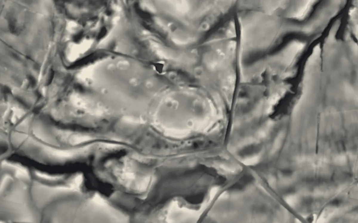
Places on the LiDAR in Lancashire
Each page shows the site on the LiDAR with its record, its location and the recorded places around it.
- BremetennacumRoman fort
- Burscough PrioryPriory
- CastercliffHillfort
- Cheetham CloseStone circle
- Clitheroe CastleCastle
- Cockersand AbbeyAbbey
- Edisford BridgeBridge
- High cross in St Wilfrid's churchyard, HaltonCross
- Loyn BridgeBridge
- Over Burrow Roman FortRoman fort
- Penwortham BridgeBridge
- Penwortham CastleCastle
- PikestonesBarrow
- Portfield hillfortHillfort
- Roman Fort and sections of Roman RoadsRoman fort
- Round LoafBarrow
- Sawley AbbeyAbbey
- Skerton BridgeBridge
- Upholland PrioryPriory
- Warton Old RectoryScheduled monument
- Wycoller HallScheduled monument
LiDAR maps of the parishes of Lancashire
One page for each of the 232 parishes, with a LiDAR picture and the recorded places inside it.
- Adlington9 recorded places
- Aighton, Bailey and Chaigley32 recorded places
- Aldcliffe-with-Stodday7 recorded places
- Altham7 recorded places
- Anderton3 recorded places
- Anglezarke11 recorded places
- Arkholme-with-Cawood8 recorded places
- Astley Village1 recorded places
- Aughton13 recorded places
- Balderstone4 recorded places
- Barley-with-Wheatley Booth8 recorded places
- Barnacre-with-Bonds26 recorded places
- Barnoldswick29 recorded places
- Barrow0 recorded places
- Barrowford19 recorded places
- Barton12 recorded places
- Bashall Eaves9 recorded places
- Bickerstaffe13 recorded places
- Billington and Langho15 recorded places
- Bispham1 recorded places
- Blackburn with Darwen82 recorded places
- Blacko6 recorded places
- Blackpool143 recorded places
- Bleasdale6 recorded places
- Bolton-by-Bowland25 recorded places
- Bolton-le-Sands19 recorded places
- Borwick24 recorded places
- Bowland Forest High10 recorded places
- Bowland Forest Low17 recorded places
- Bowland-with-Leagram3 recorded places
- Bretherton10 recorded places
- Briercliffe24 recorded places
- Brierfield7 recorded places
- Brindle10 recorded places
- Broughton16 recorded places
- Bryning-with-Warton11 recorded places
- Burnley137 recorded places
- Burrow-with-Burrow51 recorded places
- Burscough28 recorded places
- Cabus5 recorded places
- Cantsfield8 recorded places
- Carnforth25 recorded places
- Caton-with-Littledale28 recorded places
- Catterall10 recorded places
- Charnock Richard9 recorded places
- Chatburn4 recorded places
- Chipping18 recorded places
- Chorley44 recorded places
- Claughton8 recorded places
- Claughton15 recorded places
- Clayton-le-Dale3 recorded places
- Clayton-le-Woods12 recorded places
- Clitheroe26 recorded places
- Cliviger15 recorded places
- Cockerham17 recorded places
- Colne32 recorded places
- Coppull7 recorded places
- Croston8 recorded places
- Cuerdale4 recorded places
- Cuerden1 recorded places
- Dalton5 recorded places
- Darwen36 recorded places
- Dinckley2 recorded places
- Downham14 recorded places
- Downholland16 recorded places
- Dunnockshaw2 recorded places
- Dutton5 recorded places
- Earby8 recorded places
- Easington5 recorded places
- Eccleshill1 recorded places
- Eccleston11 recorded places
- Ellel38 recorded places
- Elswick5 recorded places
- Euxton15 recorded places
- Farington5 recorded places
- Fleetwood59 recorded places
- Forton18 recorded places
- Foulridge11 recorded places
- Freckleton10 recorded places
- Fylde69 recorded places
- Garstang12 recorded places
- Gisburn12 recorded places
- Gisburn Forest6 recorded places
- Goldshaw Booth9 recorded places
- Goosnargh17 recorded places
- Great Altcar10 recorded places
- Great Eccleston7 recorded places
- Great Mitton12 recorded places
- Greenhalgh-with-Thistleton7 recorded places
- Gressingham5 recorded places
- Grimsargh11 recorded places
- Grindleton5 recorded places
- Habergham Eaves5 recorded places
- Haighton4 recorded places
- Halsall20 recorded places
- Halton-with-Aughton21 recorded places
- Hambleton5 recorded places
- Hapton9 recorded places
- Heapey7 recorded places
- Heath Charnock12 recorded places
- Heaton-with-Oxcliffe5 recorded places
- Hesketh-with-Becconsall8 recorded places
- Heskin4 recorded places
- Higham-with-West Close Booth5 recorded places
- Hilldale3 recorded places
- Hoghton10 recorded places
- Hornby-with-Farleton24 recorded places
- Horton8 recorded places
- Hothersall1 recorded places
- Hutton3 recorded places
- Hyndburn96 recorded places
- Ightenhill10 recorded places
- Ingol and Tanterton4 recorded places
- Inskip-with-Sowerby8 recorded places
- Ireby6 recorded places
- Kelbrook and Sough6 recorded places
- Kirkham17 recorded places
- Kirkland20 recorded places
- Lancaster196 recorded places
- Laneshaw Bridge6 recorded places
- Lathom28 recorded places
- Lathom South3 recorded places
- Lea22 recorded places
- Leck30 recorded places
- Little Eccleston-with-Larbreck4 recorded places
- Little Hoole2 recorded places
- Little Mitton3 recorded places
- Livesey8 recorded places
- Longridge19 recorded places
- Longton6 recorded places
- Mawdesley8 recorded places
- Mearley3 recorded places
- Medlar-with-Wesham4 recorded places
- Melling-with-Wrayton6 recorded places
- Mellor6 recorded places
- Middleton10 recorded places
- Middop3 recorded places
- Morecambe47 recorded places
- Much Hoole6 recorded places
- Myerscough and Bilsborrow22 recorded places
- Nateby5 recorded places
- Nelson31 recorded places
- Nether Kellet13 recorded places
- Nether Wyresdale12 recorded places
- Newburgh15 recorded places
- Newsholme7 recorded places
- Newton13 recorded places
- Newton-with-Clifton22 recorded places
- North Meols6 recorded places
- North Turton49 recorded places
- Old Laund Booth8 recorded places
- Osbaldeston4 recorded places
- Out Rawcliffe4 recorded places
- Over Kellet20 recorded places
- Over Wyresdale20 recorded places
- Overton14 recorded places
- Padiham15 recorded places
- Parbold12 recorded places
- Paythorne7 recorded places
- Pendleton4 recorded places
- Penwortham13 recorded places
- Pilling14 recorded places
- Pleasington10 recorded places
- Preesall21 recorded places
- Preston204 recorded places
- Priest Hutton5 recorded places
- Quernmore26 recorded places
- Ramsgreave3 recorded places
- Read4 recorded places
- Reedley Hallows3 recorded places
- Ribby-with-Wrea4 recorded places
- Ribchester28 recorded places
- Rimington10 recorded places
- Rivington22 recorded places
- Roeburndale3 recorded places
- Rossendale153 recorded places
- Roughlee Booth2 recorded places
- Rufford11 recorded places
- Sabden3 recorded places
- Saint Anne's on the Sea63 recorded places
- Salesbury3 recorded places
- Salterforth8 recorded places
- Samlesbury11 recorded places
- Sawley7 recorded places
- Scarisbrick19 recorded places
- Scotforth2 recorded places
- Silverdale21 recorded places
- Simonstone7 recorded places
- Simonswood3 recorded places
- Singleton7 recorded places
- Slaidburn20 recorded places
- Slyne-with-Hest21 recorded places
- South Ribble77 recorded places
- Staining5 recorded places
- Stalmine-with-Staynall7 recorded places
- Tarleton13 recorded places
- Tatham12 recorded places
- The Yealands29 recorded places
- Thornley-with-Wheatley4 recorded places
- Thurnham59 recorded places
- Tockholes10 recorded places
- Trawden Forest17 recorded places
- Treales, Roseacre and Wharles8 recorded places
- Tunstall6 recorded places
- Twiston2 recorded places
- Ulnes Walton4 recorded places
- Up Holland28 recorded places
- Upper Rawcliffe-with-Tarnacre13 recorded places
- Waddington16 recorded places
- Warton35 recorded places
- Weeton-with-Preese9 recorded places
- Wennington6 recorded places
- West Bradford5 recorded places
- West Lancashire43 recorded places
- Westby-with-Plumptons10 recorded places
- Whalley25 recorded places
- Wheelton6 recorded places
- Whittingham11 recorded places
- Whittington16 recorded places
- Whittle-le-Woods18 recorded places
- Whitworth15 recorded places
- Wilpshire0 recorded places
- Winmarleigh7 recorded places
- Wiswell4 recorded places
- Withnell20 recorded places
- Woodplumpton14 recorded places
- Worsthorne-with-Hurstwood12 recorded places
- Worston2 recorded places
- Wray-with-Botton9 recorded places
- Wrightington19 recorded places
- Wyre55 recorded places
- Yate and Pickup Bank5 recorded places
About the LiDAR
The terrain model is made from an airborne laser survey with vegetation and buildings removed, so earthworks show as height: hillfort ramparts, barrows, Roman road banks, hollow ways and ridge and furrow. In the app the picture is computed as you change the settings, with a moveable sun, a local relief model, multidirectional hillshading and the VAT composite. See how to read a LiDAR map and what archaeology looks like on LiDAR.
Sources
- LiDAR: Environment Agency, 1 m composite DTM, Open Government Licence.
- Recorded places: the national heritage records (Historic England, Cadw, Coflein and others) as held by Waystone.
Last updated 2026-10-16.