Home LiDAR map England Hampshire
LiDAR map of Hampshire
Waystone shows the bare-earth LiDAR of Hampshire at one metre per pixel, with the 10,586 recorded historic places the heritage records hold here, the Roman roads and the Ordnance Survey six-inch maps of 1843–1913 over the same ground. Free, in a browser.
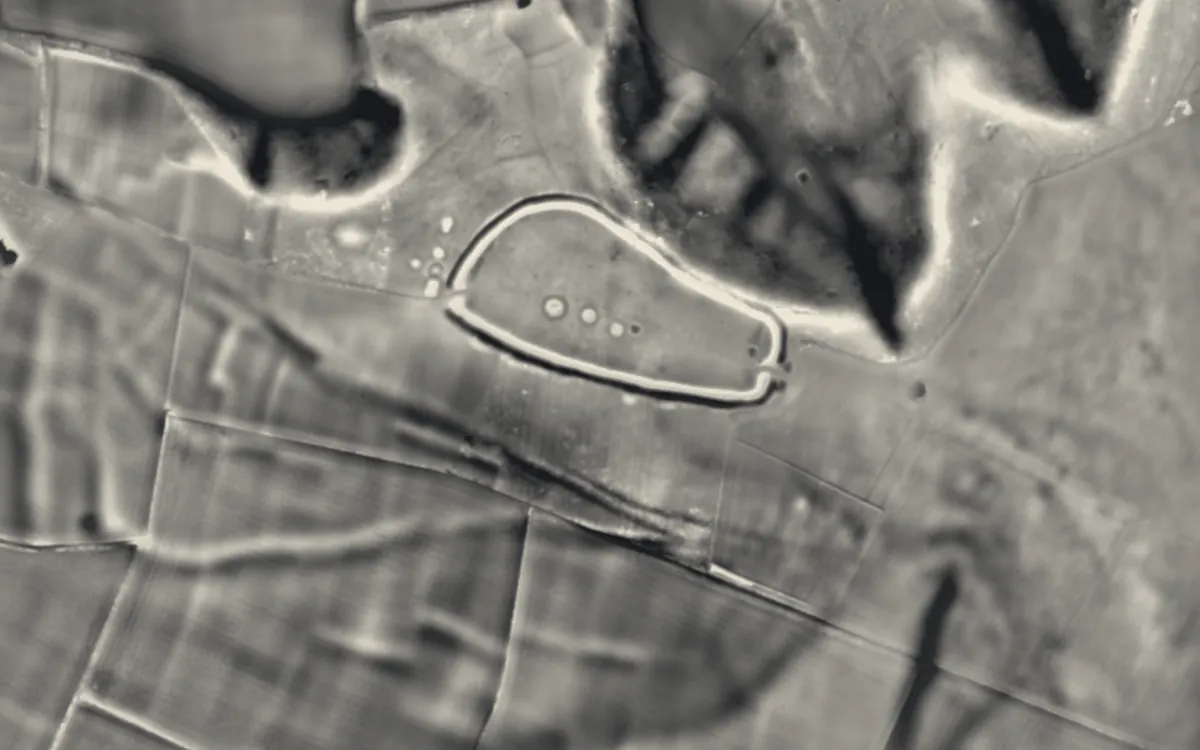
Places on the LiDAR in Hampshire
Each page shows the site on the LiDAR with its record, its location and the recorded places around it.
- Ashley CastleMotte and bailey
- BargateScheduled monument
- Basing HouseCastle
- Beaulieu AbbeyAbbey
- BevisburyHillfort
- Bishop's Waltham PalaceScheduled monument
- Bronze Age and Romano-British enclosure on Martin Down, east of Bokerley JunctionScheduled monument
- Buckland RingsHillfort
- Bullsdown CampHillfort
- Bury HillHillfort
- Calleva AtrebatumRoman site
- Calshot CastleCastle
- Canute's PalaceScheduled monument
- Castle HillHillfort
- Chilworth RingHillfort
- Danebury Hill CampHillfort
- Dunwood CampHillfort
- Flowerdown BarrowsBarrow
- Fort BlockhouseMilitary site
- Fort BrockhurstMilitary site
- Fort CumberlandMilitary site
- Fort ElsonMilitary site
- Fort FarehamMilitary site
- Fort GilkickerMilitary site
- Fort GrangeMilitary site
- Fort MoncktonMilitary site
- Fort NelsonMilitary site
- Fort SouthwickMilitary site
- Fort WidleyMilitary site
- God's House Gate and TowerScheduled monument
- Hillfort on King John's HillHillfort
- Hilsea LinesScheduled monument
- Holyrood ChurchChapel or church
- King John's PalaceScheduled monument
- KingsgateScheduled monument
- Knoll CampHillfort
- Lomer, deserted medieval settlementDeserted village
- Lumps FortMilitary site
- Multi-period site in Micheldever WoodScheduled monument
- Netley AbbeyAbbey
- Netley CastleCastle
- Norsebury RingHillfort
- Odiham CastleCastle
- Old Winchester HillHillfort
- Portchester CastleCastle
- Portsmouth Block MillsIndustrial site
- Portsmouth Garrison churchChapel or church
- Preston Candover Long BarrowBarrow
- Quarley HillHillfort
- Rockbourne Roman VillaRoman site
- Selborne PrioryPriory
- Southampton Tudor House and GardenScheduled monument
- Southsea CastleCastle
- Southwick PrioryPriory
- Spitbank FortMilitary site
- St Andrew's CastleCastle
- St Catherine's HillHillfort
- St Denys PrioryPriory
- The FrithHillfort
- The GrangeScheduled monument
- Tidbury RingHillfort
- Titchfield AbbeyAbbey
- Toothill FortHillfort
- Twyford WaterworksScheduled monument
- Warblington CastleCastle
- WestgateMilitary site
- Whitsbury CastleHillfort
- Winchester CastleCastle
- Wolvesey CastleCastle
- WoolburyHillfort
LiDAR maps of the parishes of Hampshire
One page for each of the 277 parishes, with a LiDAR picture and the recorded places inside it.
- Abbotts Ann14 recorded places
- Allbrook2 recorded places
- Alton54 recorded places
- Ampfield20 recorded places
- Amport26 recorded places
- Andover44 recorded places
- Appleshaw12 recorded places
- Ashford Hill with Headley21 recorded places
- Ashley18 recorded places
- Ashmansworth12 recorded places
- Ashurst and Colbury6 recorded places
- Awbridge19 recorded places
- Badger Farm1 recorded places
- Barton Stacey83 recorded places
- Basingstoke and Deane69 recorded places
- Baughurst17 recorded places
- Beaulieu104 recorded places
- Beauworth10 recorded places
- Beech8 recorded places
- Bentley26 recorded places
- Bentworth16 recorded places
- Bighton12 recorded places
- Binsted38 recorded places
- Bishops Sutton14 recorded places
- Bishops Waltham70 recorded places
- Bishopstoke10 recorded places
- Blackwater and Hawley26 recorded places
- Boarhunt13 recorded places
- Boldre69 recorded places
- Bossington17 recorded places
- Botley32 recorded places
- Boyatt Wood3 recorded places
- Bradley4 recorded places
- Braishfield17 recorded places
- Bramdean and Hinton Ampner59 recorded places
- Bramley25 recorded places
- Bramshaw75 recorded places
- Bramshill24 recorded places
- Bramshott and Liphook49 recorded places
- Bransgore36 recorded places
- Breamore54 recorded places
- Brockenhurst126 recorded places
- Broughton29 recorded places
- Buckholt2 recorded places
- Bullington21 recorded places
- Burghclere30 recorded places
- Buriton53 recorded places
- Burley100 recorded places
- Bursledon13 recorded places
- Candovers50 recorded places
- Chandler's Ford11 recorded places
- Charlton4 recorded places
- Chawton16 recorded places
- Cheriton18 recorded places
- Chilbolton51 recorded places
- Chilcomb16 recorded places
- Chilworth15 recorded places
- Chineham6 recorded places
- Church Crookham6 recorded places
- Clanfield32 recorded places
- Cliddesden4 recorded places
- Colden Common12 recorded places
- Colemore and Priors Dean25 recorded places
- Compton and Shawford24 recorded places
- Copythorne44 recorded places
- Corhampton and Meonstoke46 recorded places
- Crawley62 recorded places
- Crondall41 recorded places
- Crookham Village33 recorded places
- Curdridge23 recorded places
- Damerham15 recorded places
- Deane18 recorded places
- Denmead11 recorded places
- Denny Lodge242 recorded places
- Dogmersfield28 recorded places
- Droxford22 recorded places
- Dummer15 recorded places
- Durley7 recorded places
- East Boldre64 recorded places
- East Dean22 recorded places
- East Meon67 recorded places
- East Tisted15 recorded places
- East Tytherley7 recorded places
- East Woodhay15 recorded places
- Eastleigh Town56 recorded places
- Ecchinswell, Sydmonton and Bishops Green24 recorded places
- Ellingham, Harbridge and Ibsley177 recorded places
- Ellisfield5 recorded places
- Elvetham Heath7 recorded places
- Enham Alamein4 recorded places
- Eversley33 recorded places
- Ewshot82 recorded places
- Exbury and Lepe37 recorded places
- Exton51 recorded places
- Faccombe5 recorded places
- Fair Oak and Horton Heath19 recorded places
- Fareham247 recorded places
- Farleigh Wallop8 recorded places
- Farringdon12 recorded places
- Fawley132 recorded places
- Fleet17 recorded places
- Fordingbridge79 recorded places
- Four Marks4 recorded places
- Frenchmoor1 recorded places
- Froxfield and Privett44 recorded places
- Froyle29 recorded places
- Fyfield3 recorded places
- Godshill50 recorded places
- Goodworth Clatford4 recorded places
- Gosport430 recorded places
- Grateley6 recorded places
- Grayshott3 recorded places
- Greatham6 recorded places
- Greywell11 recorded places
- Hale17 recorded places
- Hamble-le-Rice55 recorded places
- Hambledon54 recorded places
- Hannington6 recorded places
- Hartley Wespall8 recorded places
- Hartley Wintney49 recorded places
- Havant247 recorded places
- Hawkley12 recorded places
- Headbourne Worthy45 recorded places
- Headley28 recorded places
- Heckfield47 recorded places
- Hedge End8 recorded places
- Herriard7 recorded places
- Highclere22 recorded places
- Hook29 recorded places
- Hordle26 recorded places
- Horndean20 recorded places
- Houghton25 recorded places
- Hound25 recorded places
- Hursley77 recorded places
- Hurstbourne Priors57 recorded places
- Hurstbourne Tarrant26 recorded places
- Hyde59 recorded places
- Hythe and Dibden26 recorded places
- Itchen Stoke and Ovington53 recorded places
- Itchen Valley94 recorded places
- Kilmiston15 recorded places
- Kimpton8 recorded places
- Kings Somborne81 recorded places
- Kings Worthy49 recorded places
- Kingsclere23 recorded places
- Kingsley11 recorded places
- Langrish29 recorded places
- Lasham7 recorded places
- Laverstoke44 recorded places
- Leckford19 recorded places
- Lindford1 recorded places
- Linkenholt4 recorded places
- Liss29 recorded places
- Litchfield and Woodcott20 recorded places
- Little Somborne18 recorded places
- Littleton and Harestock31 recorded places
- Lockerley10 recorded places
- Long Sutton13 recorded places
- Longparish51 recorded places
- Longstock21 recorded places
- Lymington and Pennington82 recorded places
- Lyndhurst46 recorded places
- Mapledurwell and Up Nately13 recorded places
- Marchwood30 recorded places
- Martin30 recorded places
- Mattingley40 recorded places
- Medstead10 recorded places
- Melchet Park and Plaitford13 recorded places
- Micheldever118 recorded places
- Michelmersh and Timsbury26 recorded places
- Milford-on-sea42 recorded places
- Minstead87 recorded places
- Monk Sherborne9 recorded places
- Monxton20 recorded places
- Mortimer West End40 recorded places
- Mottisfont32 recorded places
- Nether Wallop26 recorded places
- Netley Marsh19 recorded places
- New Alresford24 recorded places
- New Milton37 recorded places
- Newlands1 recorded places
- Newnham10 recorded places
- Newton Valence10 recorded places
- Newtown7 recorded places
- North Baddesley6 recorded places
- North Waltham21 recorded places
- Northington24 recorded places
- Nursling and Rownhams28 recorded places
- Nutley4 recorded places
- Oakley23 recorded places
- Odiham52 recorded places
- Old Alresford43 recorded places
- Old Basing and Lychpit24 recorded places
- Olivers Battery6 recorded places
- Otterbourne11 recorded places
- Over Wallop25 recorded places
- Overton67 recorded places
- Owslebury45 recorded places
- Pamber26 recorded places
- Penton Grafton11 recorded places
- Penton Mewsey7 recorded places
- Petersfield59 recorded places
- Popham24 recorded places
- Portsmouth517 recorded places
- Preston Candover12 recorded places
- Quarley7 recorded places
- Ringwood91 recorded places
- Rockbourne19 recorded places
- Romsey101 recorded places
- Rooksdown3 recorded places
- Ropley20 recorded places
- Rotherwick8 recorded places
- Rowlands Castle39 recorded places
- Rushmoor127 recorded places
- Sandleheath2 recorded places
- Selborne41 recorded places
- Shalden5 recorded places
- Shedfield16 recorded places
- Sheet4 recorded places
- Sherborne St John32 recorded places
- Sherfield English7 recorded places
- Sherfield Park4 recorded places
- Sherfield on Loddon24 recorded places
- Shipton Bellinger14 recorded places
- Silchester38 recorded places
- Smannell6 recorded places
- Soberton29 recorded places
- Sopley54 recorded places
- South Warnborough6 recorded places
- South Wonston19 recorded places
- Southampton330 recorded places
- Southwick and Widley16 recorded places
- Sparsholt51 recorded places
- St. Mary Bourne26 recorded places
- Steep18 recorded places
- Steventon13 recorded places
- Stockbridge52 recorded places
- Stratfield Saye13 recorded places
- Stratfield Turgis15 recorded places
- Stroud7 recorded places
- Swanmore10 recorded places
- Sway27 recorded places
- Tadley12 recorded places
- Tangley7 recorded places
- Thruxton9 recorded places
- Tichborne20 recorded places
- Totton and Eling51 recorded places
- Tunworth3 recorded places
- Twyford49 recorded places
- Upham20 recorded places
- Upper Clatford15 recorded places
- Upton Grey7 recorded places
- Valley Park5 recorded places
- Vernhams Dean9 recorded places
- Warnford23 recorded places
- Wellow21 recorded places
- West End19 recorded places
- West Meon55 recorded places
- West Tisted27 recorded places
- West Tytherley18 recorded places
- Weston Corbett2 recorded places
- Weston Patrick5 recorded places
- Wherwell22 recorded places
- Whitchurch58 recorded places
- Whitehill98 recorded places
- Whiteley6 recorded places
- Whitsbury7 recorded places
- Wickham and Knowle53 recorded places
- Wield6 recorded places
- Winchester149 recorded places
- Winchfield29 recorded places
- Winslade26 recorded places
- Wonston131 recorded places
- Woodgreen4 recorded places
- Wootton St. Lawrence with Ramsdell13 recorded places
- Worldham29 recorded places
- Yateley27 recorded places
About the LiDAR
The terrain model is made from an airborne laser survey with vegetation and buildings removed, so earthworks show as height: hillfort ramparts, barrows, Roman road banks, hollow ways and ridge and furrow. In the app the picture is computed as you change the settings, with a moveable sun, a local relief model, multidirectional hillshading and the VAT composite. See how to read a LiDAR map and what archaeology looks like on LiDAR.
Sources
- LiDAR: Environment Agency, 1 m composite DTM, Open Government Licence.
- Recorded places: the national heritage records (Historic England, Cadw, Coflein and others) as held by Waystone.
Last updated 2026-10-16.