Home LiDAR map England Gloucestershire
LiDAR map of Gloucestershire
Waystone shows the bare-earth LiDAR of Gloucestershire at one metre per pixel, with the 9,919 recorded historic places the heritage records hold here, the Roman roads and the Ordnance Survey six-inch maps of 1843–1913 over the same ground. Free, in a browser.
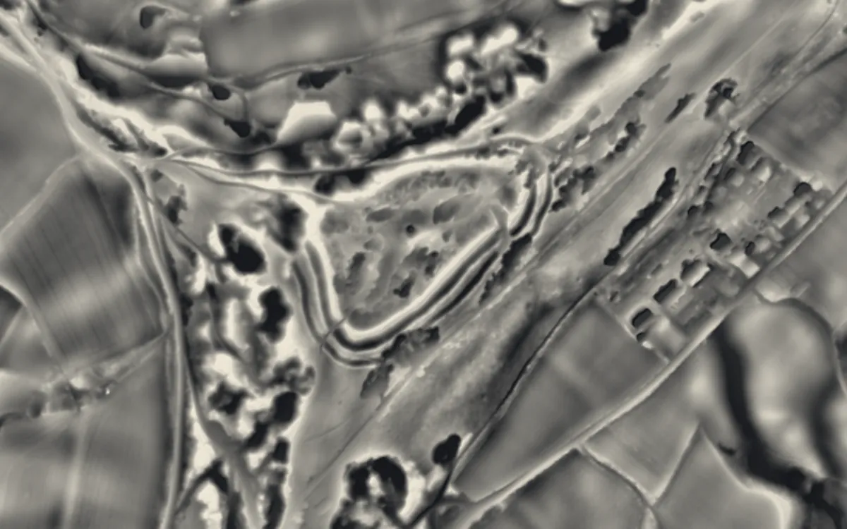
Places on the LiDAR in Gloucestershire
Each page shows the site on the LiDAR with its record, its location and the recorded places around it.
- Ashleworth Tithe BarnScheduled monument
- Belas KnapBarrow
- Beverston CastleCastle
- BlackfriarsAbbey
- Brimpsfield CastleCastle
- Chedworth Roman VillaRoman site
- Cirencester AmphitheatreRoman site
- Corinium DobunnorumScheduled monument
- Dymock Castle TumpMotte and bailey
- English Bicknor CastleMotte and bailey
- GlevumRoman fort
- Great Witcombe Roman VillaRoman site
- Hazleton long barrows, north and southBarrow
- Hewelsfield MotteMotte and bailey
- Lechlade PrioryPriory
- Leonard Stanley PrioryPriory
- Littledean CampMotte and bailey
- Llanthony SecundaPriory
- Longstone of MinchinhamptonStone circle
- Notgrove Long BarrowBarrow
- Nympsfield Long BarrowBarrow
- Our Lady's WellScheduled monument
- Over BridgeBridge
- Painswick Hill (or Kimsbury) campHillfort
- Ram Hill CollieryIndustrial site
- South Cerney CastleCastle
- Spoonley Wood Roman villaRoman site
- St Briavels CastleCastle
- St Michael's TowerChapel or church
- St Oswald's Priory, GloucesterPriory
- Stow GreenCastle
- Uley BuryHillfort
- Uley Long BarrowBarrow
- Welshbury HillHillfort
- Winchcombe AbbeyAbbey
- Windmill TumpBarrow
- Woodchester Roman VillaRoman site
LiDAR maps of the parishes of Gloucestershire
One page for each of the 320 parishes, with a LiDAR picture and the recorded places inside it.
- Acton Turville7 recorded places
- Adlestrop36 recorded places
- Alderley14 recorded places
- Alderton15 recorded places
- Aldsworth18 recorded places
- Alkington13 recorded places
- Almondsbury57 recorded places
- Alveston8 recorded places
- Alvington11 recorded places
- Ampney Crucis17 recorded places
- Ampney St. Mary6 recorded places
- Ampney St. Peter8 recorded places
- Andoversford13 recorded places
- Arlingham41 recorded places
- Ashchurch Rural20 recorded places
- Ashleworth10 recorded places
- Ashley16 recorded places
- Aston Subedge7 recorded places
- Aust28 recorded places
- Avening64 recorded places
- Awre62 recorded places
- Aylburton12 recorded places
- Badgeworth26 recorded places
- Badminton24 recorded places
- Bagendon25 recorded places
- Barnsley20 recorded places
- Barrington71 recorded places
- Batsford17 recorded places
- Baunton15 recorded places
- Berkeley45 recorded places
- Beverston32 recorded places
- Bibury70 recorded places
- Birdlip8 recorded places
- Bishop's Cleeve12 recorded places
- Bisley-with-Lypiatt64 recorded places
- Bitton47 recorded places
- Blaisdon32 recorded places
- Bledington12 recorded places
- Blockley89 recorded places
- Boddington15 recorded places
- Bourton-on-the-Hill25 recorded places
- Bourton-on-the-Water61 recorded places
- Boxwell with Leighterton28 recorded places
- Bradley Stoke8 recorded places
- Brimpsfield27 recorded places
- Brimscombe and Thrupp14 recorded places
- Broadwell21 recorded places
- Brockworth41 recorded places
- Bromesberrow15 recorded places
- Brookthorpe-with-Whaddon12 recorded places
- Buckland23 recorded places
- Cainscross14 recorded places
- Cam38 recorded places
- Chaceley6 recorded places
- Chalford34 recorded places
- Charfield22 recorded places
- Charlton Hayes11 recorded places
- Charlton Kings35 recorded places
- Chedworth59 recorded places
- Cheltenham207 recorded places
- Cherington42 recorded places
- Chipping Campden97 recorded places
- Churcham37 recorded places
- Churchdown40 recorded places
- Cinderford95 recorded places
- Cirencester165 recorded places
- Clapton4 recorded places
- Coaley21 recorded places
- Coates19 recorded places
- Coberley36 recorded places
- Cold Ashton16 recorded places
- Cold Aston14 recorded places
- Coleford89 recorded places
- Colesbourne21 recorded places
- Coln St. Aldwyns35 recorded places
- Coln St. Dennis31 recorded places
- Compton Abdale18 recorded places
- Condicote17 recorded places
- Corse14 recorded places
- Cowley11 recorded places
- Cranham31 recorded places
- Cromhall42 recorded places
- Cutsdean7 recorded places
- Daglingworth16 recorded places
- Deerhurst27 recorded places
- Didmarton33 recorded places
- Dodington27 recorded places
- Donnington7 recorded places
- Dowdeswell32 recorded places
- Down Ampney18 recorded places
- Down Hatherley16 recorded places
- Downend and Bromley Heath17 recorded places
- Doynton30 recorded places
- Driffield15 recorded places
- Drybrook59 recorded places
- Dumbleton27 recorded places
- Duntisbourne Abbots27 recorded places
- Duntisbourne Rouse23 recorded places
- Dursley27 recorded places
- Dymock61 recorded places
- Dyrham and Hinton30 recorded places
- Eastington30 recorded places
- Eastleach31 recorded places
- Ebrington20 recorded places
- Edgeworth10 recorded places
- Elkstone19 recorded places
- Elmore40 recorded places
- Elmstone Hardwicke6 recorded places
- Emersons Green8 recorded places
- English Bicknor43 recorded places
- Evenlode6 recorded places
- Fairford52 recorded places
- Falfield19 recorded places
- Farmington26 recorded places
- Filton42 recorded places
- Forthampton18 recorded places
- Frampton Cotterell16 recorded places
- Frampton on Severn41 recorded places
- Fretherne with Saul33 recorded places
- Frocester21 recorded places
- Gloucester331 recorded places
- Gorsley and Kilcot7 recorded places
- Gotherington13 recorded places
- Great Oldbury1 recorded places
- Great Rissington28 recorded places
- Great Witcombe8 recorded places
- Gretton7 recorded places
- Guiting Power28 recorded places
- Ham and Stone37 recorded places
- Hamfallow10 recorded places
- Hampnett22 recorded places
- Hanham3 recorded places
- Hanham Abbots11 recorded places
- Hardwicke19 recorded places
- Harescombe10 recorded places
- Haresfield24 recorded places
- Hartpury21 recorded places
- Hasfield17 recorded places
- Hatherop8 recorded places
- Hawkesbury56 recorded places
- Hawling27 recorded places
- Hazleton25 recorded places
- Hewelsfield and Brockweir29 recorded places
- Highnam32 recorded places
- Hill14 recorded places
- Hillesley and Tresham25 recorded places
- Hinton25 recorded places
- Horsley17 recorded places
- Horton27 recorded places
- Hucclecote9 recorded places
- Huntley18 recorded places
- Hunts Grove2 recorded places
- Icomb11 recorded places
- Innsworth9 recorded places
- Iron Acton20 recorded places
- Kemble and Ewen25 recorded places
- Kempley8 recorded places
- Kempsford18 recorded places
- King's Stanley33 recorded places
- Kingscote49 recorded places
- Kingswood10 recorded places
- Kingswood11 recorded places
- Lechlade44 recorded places
- Leckhampton with Warden Hill21 recorded places
- Leigh12 recorded places
- Leonard Stanley13 recorded places
- Little Rissington13 recorded places
- Littledean56 recorded places
- Long Newnton20 recorded places
- Longborough29 recorded places
- Longford5 recorded places
- Longhope34 recorded places
- Longney and Epney28 recorded places
- Lower Slaughter19 recorded places
- Lydbrook45 recorded places
- Lydney139 recorded places
- Maisemore10 recorded places
- Maiseyhampton7 recorded places
- Marshfield57 recorded places
- Maugersbury8 recorded places
- Mickleton17 recorded places
- Minchinhampton198 recorded places
- Minsterworth18 recorded places
- Miserden42 recorded places
- Mitcheldean73 recorded places
- Moreton Valence14 recorded places
- Moreton-in-Marsh51 recorded places
- Nailsworth40 recorded places
- Naunton30 recorded places
- Newent36 recorded places
- Newland84 recorded places
- Newnham56 recorded places
- North Cerney62 recorded places
- North Nibley37 recorded places
- Northleach with Eastington86 recorded places
- Northway4 recorded places
- Norton12 recorded places
- Notgrove10 recorded places
- Nympsfield22 recorded places
- Oddington13 recorded places
- Oldbury-upon-Severn27 recorded places
- Oldland12 recorded places
- Olveston26 recorded places
- Owlpen1 recorded places
- Oxenhall16 recorded places
- Oxenton14 recorded places
- Ozleworth11 recorded places
- Painswick104 recorded places
- Patchway13 recorded places
- Pauntley16 recorded places
- Pilning and Severn Beach31 recorded places
- Pitchcombe12 recorded places
- Poole Keynes7 recorded places
- Poulton14 recorded places
- Prescott9 recorded places
- Prestbury29 recorded places
- Preston26 recorded places
- Pucklechurch35 recorded places
- Quedgeley21 recorded places
- Quenington14 recorded places
- Randwick and Westrip13 recorded places
- Rangeworthy17 recorded places
- Redmarley D'Abitot19 recorded places
- Rendcomb23 recorded places
- Rockhampton14 recorded places
- Rodborough34 recorded places
- Rodmarton44 recorded places
- Ruardean34 recorded places
- Rudford and Highleadon13 recorded places
- Ruspidge and Soudley39 recorded places
- Saintbury15 recorded places
- Sandhurst11 recorded places
- Sapperton30 recorded places
- Sevenhampton24 recorded places
- Sezincote24 recorded places
- Sherborne46 recorded places
- Shipton36 recorded places
- Shipton Moyne21 recorded places
- Shurdington19 recorded places
- Siddington8 recorded places
- Siston23 recorded places
- Slimbridge36 recorded places
- Snowshill20 recorded places
- Sodbury46 recorded places
- Somerford Keynes18 recorded places
- South Cerney29 recorded places
- Southam33 recorded places
- Southrop9 recorded places
- St. Briavels67 recorded places
- Standish16 recorded places
- Stanton15 recorded places
- Stanway40 recorded places
- Staple Hill and Mangotsfield11 recorded places
- Staunton9 recorded places
- Staunton Coleford23 recorded places
- Staverton13 recorded places
- Stinchcombe28 recorded places
- Stoke Gifford44 recorded places
- Stoke Lodge and The Common1 recorded places
- Stoke Orchard21 recorded places
- Stoke Park and Cheswick20 recorded places
- Stonehouse41 recorded places
- Stow-on-the-Wold29 recorded places
- Stroud76 recorded places
- Sudeley27 recorded places
- Swell55 recorded places
- Swindon10 recorded places
- Syde3 recorded places
- Taynton26 recorded places
- Teddington12 recorded places
- Temple Guiting99 recorded places
- Tetbury89 recorded places
- Tetbury Upton25 recorded places
- Tewkesbury120 recorded places
- Thornbury40 recorded places
- Tibberton12 recorded places
- Tidenham128 recorded places
- Tirley11 recorded places
- Toddington17 recorded places
- Todenham19 recorded places
- Tormarton51 recorded places
- Tortworth14 recorded places
- Turkdean19 recorded places
- Twigworth4 recorded places
- Twyning21 recorded places
- Tytherington and Itchington25 recorded places
- Uckington11 recorded places
- Uley52 recorded places
- Up Hatherley6 recorded places
- Upleadon10 recorded places
- Upper Rissington1 recorded places
- Upper Slaughter32 recorded places
- Upton St. Leonards46 recorded places
- West Dean217 recorded places
- Westbury-on-Severn96 recorded places
- Westcote8 recorded places
- Westerleigh and Coalpit Heath42 recorded places
- Weston Subedge18 recorded places
- Westonbirt with Lasborough38 recorded places
- Wheatpieces1 recorded places
- Whiteshill and Ruscombe4 recorded places
- Whitminster17 recorded places
- Whittington21 recorded places
- Wick Rissington11 recorded places
- Wick and Abson26 recorded places
- Wickwar63 recorded places
- Willersey10 recorded places
- Winchcombe41 recorded places
- Windrush39 recorded places
- Winson13 recorded places
- Winstone11 recorded places
- Winterbourne48 recorded places
- Withington46 recorded places
- Woodchester30 recorded places
- Woodmancote7 recorded places
- Woolaston29 recorded places
- Wormington9 recorded places
- Wotton-under-Edge71 recorded places
- Yanworth21 recorded places
- Yate59 recorded places
About the LiDAR
The terrain model is made from an airborne laser survey with vegetation and buildings removed, so earthworks show as height: hillfort ramparts, barrows, Roman road banks, hollow ways and ridge and furrow. In the app the picture is computed as you change the settings, with a moveable sun, a local relief model, multidirectional hillshading and the VAT composite. See how to read a LiDAR map and what archaeology looks like on LiDAR.
Sources
- LiDAR: Environment Agency, 1 m composite DTM, Open Government Licence.
- Recorded places: the national heritage records (Historic England, Cadw, Coflein and others) as held by Waystone.
Last updated 2026-10-16.