Home LiDAR map England Herefordshire
LiDAR map of Herefordshire
Waystone shows the bare-earth LiDAR of Herefordshire at one metre per pixel, with the 2,631 recorded historic places the heritage records hold here, the Roman roads and the Ordnance Survey six-inch maps of 1843–1913 over the same ground. Free, in a browser.
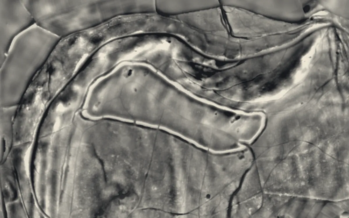
Places on the LiDAR in Herefordshire
Each page shows the site on the LiDAR with its record, its location and the recorded places around it.
- Aconbury CampHillfort
- AriconiumScheduled monument
- Arthur's Stone, HerefordshireBarrow
- Bach CampHillfort
- Brampton Bryan CastleCastle
- Brandon Camp large univallate hillfort and ring ditch 350m north east of Warwick House.Hillfort
- Bredwardine CastleCastle
- Bronsil CastleManor house
- Capler CampHillfort
- Clifford Castle and BarbicanCastle
- Craswall PrioryPriory
- Croft AmbreyHillfort
- Dinedor CampHillfort
- Dore AbbeyAbbey
- Dorstone CastleMotte and bailey
- Dovecot About 80 Yards South East Of The Church Of St MichaelScheduled monument
- Dovecot at Court HouseScheduled monument
- Dry Arch Bridge 300yds (270m) NE of St Giles' ChurchBridge
- Eardisley CastleCastle
- Ewyas Harold CastleMotte and bailey
- Flanesford PrioryPriory
- Goodrich CastleCastle
- Hereford CastleCastle
- Hertford Blackfriars PrioryPriory
- Huntington CastleCastle
- Ivington CampHillfort
- Kerne BridgeBridge
- King Arthur's CaveScheduled monument
- Limebrook PrioryPriory
- Longtown CastleCastle
- Mortimer's Castle N and E of St Bartholomew's ChurchCastle
- Poston CampHillfort
- Roman fortRoman fort
- Snodhill CastleMotte and bailey
- Sutton Walls Hill FortHillfort
- Wapley HillHillfort
- Weobley CastleMotte and bailey
- Wigmore AbbeyAbbey
- Wigmore CastleCastle
- Wilton BridgeBridge
- Wilton CastleCastle
- Wye Bridge, HerefordBridge
LiDAR maps of the parishes of Herefordshire
One page for each of the 235 parishes, with a LiDAR picture and the recorded places inside it.
- Abbey Dore11 recorded places
- Aconbury4 recorded places
- Acton Beauchamp4 recorded places
- Adforton17 recorded places
- Allensmore12 recorded places
- Almeley18 recorded places
- Ashperton6 recorded places
- Aston Ingham21 recorded places
- Avenbury5 recorded places
- Aylton2 recorded places
- Aymestrey22 recorded places
- Bacton9 recorded places
- Ballingham7 recorded places
- Bartestree5 recorded places
- Belmont Rural4 recorded places
- Birley with Upper Hill8 recorded places
- Bishop's Frome20 recorded places
- Bishopstone5 recorded places
- Blakemere3 recorded places
- Bodenham18 recorded places
- Bolstone6 recorded places
- Bosbury12 recorded places
- Brampton Abbotts4 recorded places
- Brampton Bryan6 recorded places
- Bredenbury6 recorded places
- Bredwardine18 recorded places
- Breinton6 recorded places
- Bridge Sollers7 recorded places
- Bridstow9 recorded places
- Brilley8 recorded places
- Brimfield6 recorded places
- Brinsop and Wormsley17 recorded places
- Brobury with Monnington on Wye8 recorded places
- Brockhampton (Bromyard Bringsty Ward)9 recorded places
- Brockhampton (Old Gore Ward)10 recorded places
- Bromyard and Winslow22 recorded places
- Buckton and Coxall11 recorded places
- Burghill6 recorded places
- Burrington7 recorded places
- Byford5 recorded places
- Byton6 recorded places
- Callow2 recorded places
- Canon Frome6 recorded places
- Canon Pyon7 recorded places
- Castle Frome8 recorded places
- Clehonger9 recorded places
- Clifford50 recorded places
- Coddington11 recorded places
- Collington3 recorded places
- Colwall54 recorded places
- Combe2 recorded places
- Cradley and Storridge29 recorded places
- Craswall9 recorded places
- Credenhill12 recorded places
- Croft and Yarpole20 recorded places
- Cusop9 recorded places
- Dewsall2 recorded places
- Dilwyn15 recorded places
- Dinedor7 recorded places
- Dinmore5 recorded places
- Docklow and Hampton Wafer6 recorded places
- Donnington18 recorded places
- Dormington4 recorded places
- Dorstone17 recorded places
- Downton9 recorded places
- Dulas3 recorded places
- Eardisland14 recorded places
- Eardisley21 recorded places
- Eastnor45 recorded places
- Eaton Bishop8 recorded places
- Edvin Loach and Saltmarshe7 recorded places
- Edwyn Ralph3 recorded places
- Eggleton2 recorded places
- Elton4 recorded places
- Evesbatch3 recorded places
- Ewyas Harold8 recorded places
- Eye, Moreton and Ashton10 recorded places
- Eyton4 recorded places
- Felton7 recorded places
- Ford and Stoke Prior15 recorded places
- Fownhope14 recorded places
- Foy9 recorded places
- Ganarew6 recorded places
- Garway9 recorded places
- Goodrich55 recorded places
- Grafton6 recorded places
- Grendon Bishop5 recorded places
- Hampton Bishop7 recorded places
- Hampton Charles1 recorded places
- Harewood4 recorded places
- Hatfield and Newhampton5 recorded places
- Haywood4 recorded places
- Hentland13 recorded places
- Hereford119 recorded places
- Holme Lacy9 recorded places
- Holmer & Shelwick7 recorded places
- Hope Mansell9 recorded places
- Hope under Dinmore14 recorded places
- How Caple5 recorded places
- Humber11 recorded places
- Huntington9 recorded places
- Kenchester10 recorded places
- Kentchurch13 recorded places
- Kilpeck25 recorded places
- Kimbolton11 recorded places
- King's Pyon7 recorded places
- Kings Caple7 recorded places
- Kingsland23 recorded places
- Kingstone9 recorded places
- Kington39 recorded places
- Kington Rural18 recorded places
- Kinnersley9 recorded places
- Kinsham6 recorded places
- Knill3 recorded places
- Laysters6 recorded places
- Lea12 recorded places
- Ledbury83 recorded places
- Leinthall Starkes3 recorded places
- Leintwardine19 recorded places
- Leominster59 recorded places
- Letton6 recorded places
- Lingen8 recorded places
- Linton (Bromyard Bringsty Ward)8 recorded places
- Linton (Penyard Ward)25 recorded places
- Little Birch2 recorded places
- Little Cowarne4 recorded places
- Little Dewchurch3 recorded places
- Little Hereford11 recorded places
- Little Marcle7 recorded places
- Llancillo1 recorded places
- Llandinabo9 recorded places
- Llangarron45 recorded places
- Llanrothal5 recorded places
- Llanveynoe7 recorded places
- Llanwarne7 recorded places
- Longtown20 recorded places
- Lower Bullingham8 recorded places
- Lower Harpton4 recorded places
- Lucton5 recorded places
- Lugwardine14 recorded places
- Luston4 recorded places
- Lyonshall14 recorded places
- Madley15 recorded places
- Mansell Gamage5 recorded places
- Mansell Lacy5 recorded places
- Marden24 recorded places
- Marstow13 recorded places
- Mathon18 recorded places
- Michaelchurch Escley8 recorded places
- Middleton on the Hill4 recorded places
- Moccas10 recorded places
- Monkland and Stretford6 recorded places
- Mordiford7 recorded places
- Moreton Jeffries3 recorded places
- Moreton on Lugg3 recorded places
- Much Birch9 recorded places
- Much Cowarne9 recorded places
- Much Dewchurch9 recorded places
- Much Marcle24 recorded places
- Munsley5 recorded places
- Newton (Golden Valley South Ward)3 recorded places
- Newton (Queenswood Ward)1 recorded places
- Norton4 recorded places
- Norton Canon2 recorded places
- Ocle Pychard8 recorded places
- Orcop5 recorded places
- Orleton7 recorded places
- Pembridge36 recorded places
- Pencombe with Grendon Warren7 recorded places
- Pencoyd2 recorded places
- Peterchurch13 recorded places
- Peterstow9 recorded places
- Pipe Aston4 recorded places
- Pipe and Lyde7 recorded places
- Pixley4 recorded places
- Preston Wynne7 recorded places
- Preston on Wye6 recorded places
- Pudlestone5 recorded places
- Putley9 recorded places
- Richards Castle (Hereford)5 recorded places
- Rodd, Nash and Little Brampton8 recorded places
- Ross-on-Wye31 recorded places
- Rowlstone5 recorded places
- Sarnesfield6 recorded places
- Sellack16 recorded places
- Shobdon16 recorded places
- Sollers Hope5 recorded places
- St. Margarets6 recorded places
- St. Weonards9 recorded places
- Stanford Bishop4 recorded places
- Stapleton2 recorded places
- Staunton on Arrow9 recorded places
- Staunton on Wye8 recorded places
- Stoke Edith10 recorded places
- Stoke Lacy8 recorded places
- Stretton Grandison6 recorded places
- Stretton Sugwas7 recorded places
- Sutton14 recorded places
- Tarrington10 recorded places
- Tedstone Delamere3 recorded places
- Tedstone Wafer5 recorded places
- Thornbury6 recorded places
- Thruxton4 recorded places
- Titley13 recorded places
- Tretire with Michaelchurch10 recorded places
- Turnastone5 recorded places
- Tyberton5 recorded places
- Ullingswick6 recorded places
- Upper Sapey5 recorded places
- Upton Bishop12 recorded places
- Vowchurch13 recorded places
- Wacton4 recorded places
- Walford39 recorded places
- Walford, Letton and Newton6 recorded places
- Walterstone4 recorded places
- Wellington12 recorded places
- Wellington Heath6 recorded places
- Welsh Bicknor16 recorded places
- Welsh Newton10 recorded places
- Weobley31 recorded places
- Westhide6 recorded places
- Weston Beggard4 recorded places
- Weston under Penyard34 recorded places
- Whitbourne18 recorded places
- Whitchurch17 recorded places
- Whitney-on-Wye5 recorded places
- Wigmore13 recorded places
- Willersley and Winforton10 recorded places
- Willey3 recorded places
- Withington15 recorded places
- Wolferlow3 recorded places
- Woolhope6 recorded places
- Yarkhill5 recorded places
- Yatton5 recorded places
- Yazor11 recorded places
About the LiDAR
The terrain model is made from an airborne laser survey with vegetation and buildings removed, so earthworks show as height: hillfort ramparts, barrows, Roman road banks, hollow ways and ridge and furrow. In the app the picture is computed as you change the settings, with a moveable sun, a local relief model, multidirectional hillshading and the VAT composite. See how to read a LiDAR map and what archaeology looks like on LiDAR.
Sources
- LiDAR: Environment Agency, 1 m composite DTM, Open Government Licence.
- Recorded places: the national heritage records (Historic England, Cadw, Coflein and others) as held by Waystone.
Last updated 2026-10-16.