Home LiDAR map England Buckinghamshire
LiDAR map of Buckinghamshire
Waystone shows the bare-earth LiDAR of Buckinghamshire at one metre per pixel, with the 3,368 recorded historic places the heritage records hold here, the Roman roads and the Ordnance Survey six-inch maps of 1843–1913 over the same ground. Free, in a browser.
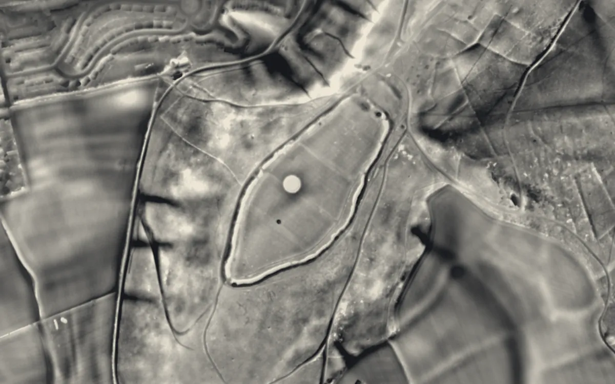
Places on the LiDAR in Buckinghamshire
Each page shows the site on the LiDAR with its record, its location and the recorded places around it.
- Boddington Camp: a slight univallate hillfort on the summit of Boddington HillHillfort
- Bolbec CastleMotte and bailey
- Castlethorpe CastleMotte and bailey
- Cholesbury CampHillfort
- Cymbeline's CastleMotte and bailey
- Hawridge Court ringworkMotte and bailey
- Lavendon AbbeyAbbey
- Lavendon CastleMotte and bailey
- Ravenstone PrioryPriory
- Snelshall PrioryPriory
- Thornborough BridgeBridge
- Tickford BridgeBridge
- Weston Turville CastleMotte and bailey
- Whiteleaf CrossScheduled monument
LiDAR maps of the parishes of Buckinghamshire
One page for each of the 223 parishes, with a LiDAR picture and the recorded places inside it.
- Abbey Hill4 recorded places
- Addington8 recorded places
- Adstock12 recorded places
- Akeley7 recorded places
- Amersham50 recorded places
- Ashendon5 recorded places
- Ashley Green7 recorded places
- Aston Abbotts8 recorded places
- Aston Clinton14 recorded places
- Aston Sandford2 recorded places
- Astwood18 recorded places
- Aylesbury85 recorded places
- Barton Hartshorn6 recorded places
- Beachampton10 recorded places
- Beaconsfield41 recorded places
- Berryfields5 recorded places
- Biddlesden34 recorded places
- Bierton7 recorded places
- Bledlow-cum-Saunderton37 recorded places
- Bletchley and Fenny Stratford30 recorded places
- Boarstall9 recorded places
- Bow Brickhill7 recorded places
- Bradenham15 recorded places
- Bradwell5 recorded places
- Brill19 recorded places
- Broughton5 recorded places
- Broughton Hamlet3 recorded places
- Buckingham56 recorded places
- Buckingham Park1 recorded places
- Buckinghamshire70 recorded places
- Buckland10 recorded places
- Burnham43 recorded places
- Calvert Green3 recorded places
- Calverton9 recorded places
- Campbell Park15 recorded places
- Castlethorpe7 recorded places
- Central Milton Keynes21 recorded places
- Chalfont St Giles26 recorded places
- Chalfont St. Peter20 recorded places
- Charndon2 recorded places
- Chartridge8 recorded places
- Chearsley7 recorded places
- Cheddington9 recorded places
- Chenies8 recorded places
- Chepping Wycombe17 recorded places
- Chesham39 recorded places
- Chesham Bois5 recorded places
- Chetwode11 recorded places
- Chicheley20 recorded places
- Chilton7 recorded places
- Cholesbury-cum-St Leonards12 recorded places
- Clifton Reynes18 recorded places
- Cold Brayfield5 recorded places
- Coldharbour1 recorded places
- Coleshill6 recorded places
- Creslow4 recorded places
- Cublington5 recorded places
- Cuddington8 recorded places
- Denham41 recorded places
- Dinton-with-Ford and Upton22 recorded places
- Dorney16 recorded places
- Dorton7 recorded places
- Downley2 recorded places
- Drayton Beauchamp6 recorded places
- Drayton Parslow14 recorded places
- Dunton3 recorded places
- East Claydon13 recorded places
- Edgcott3 recorded places
- Edlesborough15 recorded places
- Ellesborough25 recorded places
- Emberton19 recorded places
- Fairfields2 recorded places
- Farnham Royal13 recorded places
- Fawley14 recorded places
- Fleet Marston5 recorded places
- Foscott5 recorded places
- Fulmer7 recorded places
- Gawcott with Lenborough15 recorded places
- Gayhurst12 recorded places
- Gerrards Cross17 recorded places
- Granborough5 recorded places
- Great Brickhill8 recorded places
- Great Horwood20 recorded places
- Great Linford16 recorded places
- Great Marlow19 recorded places
- Great Missenden40 recorded places
- Great and Little Hampden15 recorded places
- Great and Little Kimble cum Marsh17 recorded places
- Grendon Underwood12 recorded places
- Haddenham24 recorded places
- Halton21 recorded places
- Hambleden30 recorded places
- Hanslope14 recorded places
- Hardmead21 recorded places
- Hardwick5 recorded places
- Haversham-cum-Little Linford11 recorded places
- Hazlemere2 recorded places
- Hedgerley6 recorded places
- Hedsor6 recorded places
- Hillesden25 recorded places
- Hoggeston7 recorded places
- Hogshaw4 recorded places
- Hughenden19 recorded places
- Hulcott2 recorded places
- Ibstone6 recorded places
- Ickford6 recorded places
- Iver29 recorded places
- Ivinghoe32 recorded places
- Kents Hill, Monkston and Brinklow4 recorded places
- Kingsbrook2 recorded places
- Kingsey5 recorded places
- Kingswood1 recorded places
- Lacey Green9 recorded places
- Lane End11 recorded places
- Lathbury3 recorded places
- Latimer and Ley Hill10 recorded places
- Lavendon30 recorded places
- Leckhampstead12 recorded places
- Lillingstone Dayrell with Luffield Abbey12 recorded places
- Lillingstone Lovell9 recorded places
- Little Brickhill6 recorded places
- Little Chalfont4 recorded places
- Little Horwood18 recorded places
- Little Marlow15 recorded places
- Little Missenden16 recorded places
- Long Crendon18 recorded places
- Longwick-cum-Ilmer16 recorded places
- Loughton & Great Holm9 recorded places
- Ludgershall10 recorded places
- Maids Moreton15 recorded places
- Marlow52 recorded places
- Marlow Bottom2 recorded places
- Marsh Gibbon10 recorded places
- Marsworth23 recorded places
- Medmenham19 recorded places
- Mentmore13 recorded places
- Middle Claydon16 recorded places
- Milton Keynes8 recorded places
- Moulsoe8 recorded places
- Mursley16 recorded places
- Nash5 recorded places
- Nether Winchendon8 recorded places
- New Bradwell6 recorded places
- Newport Pagnell34 recorded places
- Newton Blossomville6 recorded places
- Newton Longville9 recorded places
- North Crawley20 recorded places
- North Marston4 recorded places
- Oakley12 recorded places
- Old Woughton7 recorded places
- Olney35 recorded places
- Oving6 recorded places
- Padbury27 recorded places
- Penn17 recorded places
- Piddington and Wheeler End6 recorded places
- Pitchcott2 recorded places
- Pitstone12 recorded places
- Poundon8 recorded places
- Preston Bissett16 recorded places
- Princes Risborough34 recorded places
- Quainton16 recorded places
- Radclive-cum-Chackmore29 recorded places
- Radnage6 recorded places
- Ravenstone6 recorded places
- Seer Green5 recorded places
- Shabbington4 recorded places
- Shalstone21 recorded places
- Shenley Brook End10 recorded places
- Shenley Church End11 recorded places
- Sherington11 recorded places
- Simpson and Ashland7 recorded places
- Slapton14 recorded places
- Soulbury41 recorded places
- Stantonbury12 recorded places
- Steeple Claydon25 recorded places
- Stewkley27 recorded places
- Stoke Goldington5 recorded places
- Stoke Hammond15 recorded places
- Stoke Mandeville4 recorded places
- Stoke Poges21 recorded places
- Stokenchurch16 recorded places
- Stone with Bishopstone and Hartwell26 recorded places
- Stony Stratford39 recorded places
- Stowe88 recorded places
- Swanbourne17 recorded places
- Taplow38 recorded places
- The Lee10 recorded places
- Thornborough19 recorded places
- Thornton6 recorded places
- Tingewick27 recorded places
- Turville9 recorded places
- Turweston8 recorded places
- Twyford12 recorded places
- Tyringham and Filgrave16 recorded places
- Upper Winchendon8 recorded places
- Waddesdon54 recorded places
- Walton8 recorded places
- Warrington4 recorded places
- Water Stratford10 recorded places
- Watermead1 recorded places
- Wavendon12 recorded places
- Weedon5 recorded places
- Wendover34 recorded places
- West Bletchley21 recorded places
- West Wycombe33 recorded places
- Westbury22 recorded places
- Westcott11 recorded places
- Weston Turville14 recorded places
- Weston Underwood18 recorded places
- Wexham16 recorded places
- Whaddon26 recorded places
- Whitchurch12 recorded places
- Whitehouse1 recorded places
- Wing19 recorded places
- Wingrave with Rowsham8 recorded places
- Winslow24 recorded places
- Woburn Sands3 recorded places
- Wolverton and Greenleys28 recorded places
- Wooburn24 recorded places
- Woodham2 recorded places
- Worminghall8 recorded places
- Wotton Underwood17 recorded places
- Woughton on the Green5 recorded places
About the LiDAR
The terrain model is made from an airborne laser survey with vegetation and buildings removed, so earthworks show as height: hillfort ramparts, barrows, Roman road banks, hollow ways and ridge and furrow. In the app the picture is computed as you change the settings, with a moveable sun, a local relief model, multidirectional hillshading and the VAT composite. See how to read a LiDAR map and what archaeology looks like on LiDAR.
Sources
- LiDAR: Environment Agency, 1 m composite DTM, Open Government Licence.
- Recorded places: the national heritage records (Historic England, Cadw, Coflein and others) as held by Waystone.
Last updated 2026-10-16.