Research

The research behind the map.

Waystone is also a research project: a detector for earthworks in the LiDAR, taught by machine learning, and a machine reading of the first Ordnance Survey.

01The detector

An earthwork detector, taught by machine learning.

An earthwork is a bank, ditch, mound or platform left by past building. LiDAR is a laser survey flown from an aircraft that measures the height of the ground. Bare-earth LiDAR has the vegetation taken out, leaving the shape of the ground. An earthwork shows in it as relief.

Waystone is training a machine-learning model — a program shown many examples and left to work out what they have in common — on 1,865 scheduled monuments in England. A scheduled monument is a site protected by law and listed on the national heritage register, the list Historic England keeps.

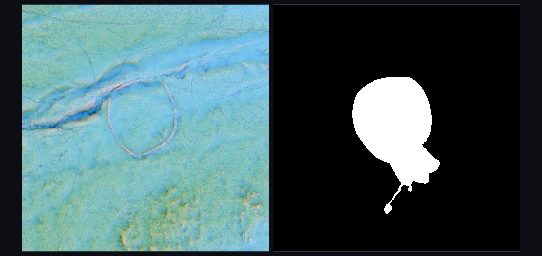
Each monument is cut from the national LiDAR as one tile of five readings: local relief, openness, sky-view factor, slope and hillshade. Its scheduled boundary becomes the mask, a black-and-white image white on the monument, and the mask is the answer the model is marked against.

It is tested on ground it was not trained on, a method called spatial cross-validation, so it cannot mark its own homework. It produces a ranking for a professional to assess, and never announces a discovery. It is in training, and not in the app.
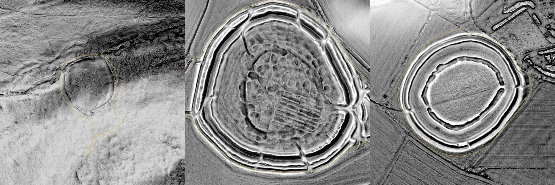
Three square greyscale LiDAR frames side by side, each with a thin gold line drawn round the monument's scheduled boundary. On the left a small ring-shaped enclosure on a hillside, the gold line running on south beyond it; in the middle and on the right, enclosures ringed by concentric banks and ditches.
Grimspound in Devon, Yarnbury camp and Figsbury Ring in Wiltshire: three of the 1,865 training monuments, drawn by Waystone’s VAT in the app itself, each frame 520 m of ground. The gold line on each is that monument’s scheduled boundary, drawn by the map from the Historic England polygon. Terrain: Environment Agency National LiDAR Programme, Open Government Licence · boundaries: Historic England, Open Government Licence v3.0 · rendering: Waystone’s VAT.
Two square panels: on the left a LiDAR tile showing a ring-shaped earthwork, on the right the same area as a black image with a white patch where the monument's boundary lies
One training example as its two files: the LiDAR tile at Grimspound and its mask, in the model’s colours, not the map’s. Terrain: Environment Agency National LiDAR Programme, Open Government Licence · boundary: Historic England, Open Government Licence v3.0.
02The gazetteer

A semantic gazetteer: the first Ordnance Survey, read as data.

The Ordnance Survey is Britain’s national mapping agency. Its six-inch first survey — six inches of map to a mile of ground — was made between the 1840s and the 1890s. It is the map Waystone lays over the ground today.

A gazetteer is a list of place names with their positions; a semantic gazetteer records what each name denotes. An antiquity — the Ordnance Survey’s word for an old man-made thing on the ground, such as a burial mound. A farm. A stream. Survey furniture, such as a bench mark. And, on a first-edition sheet, the period the surveyor assigned, read from the typeface.

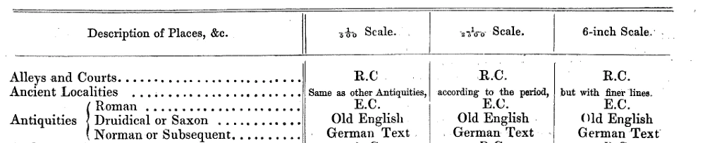
The Survey’s circular OS 404 of November 1881, Character of Writing, told the engravers which typeface went with which kind of name. Antiquities were set by period: Egyptian capitals for Roman, Old English for Druidical or Saxon (prehistoric or Saxon), German Text for Norman and later (medieval).

A photographic copy of part of a printed Victorian table: a heading row with three scale columns, 1/500, 1/2500 and 6-inch; two rows above; and a bracketed three-line entry reading Antiquities, Roman, Druidical or Saxon, Norman or Subsequent, with a typeface named against each period in every column
The antiquities block of OS 404, with the typeface named against each period in every scale column. OS 404 (1881) · National Library of Scotland Map X3.234.

Waystone is reading the whole series by machine: about 9.4 million word detections over fourteen source files. From the first file, 234,304 labels have been curated. Among them are 153,459 in England, 61,822 in Scotland and 18,980 in Wales.

Every label becomes a point with coordinates, its words, its kind and its period: a vectorised landscape, data that can be counted and set beside today’s record. Where an 1880s sheet names an antiquity today’s record does not hold, that place becomes a candidate for the detector. That is predictive archaeology here: an ordered list of ground worth looking at, not a claim.

The typeface classifier reads a letterform and returns a period. It is in training, and not in the app. Forty Dartmoor labels have been checked by eye against the OS 404 plate; thirty-nine lie inside the window below.
Read a sheet.

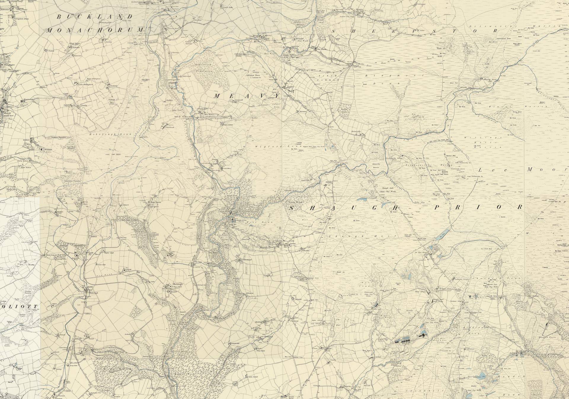
The window below is the six-inch first edition over south-west Dartmoor, streamed from the National Library of Scotland. It covers the Meavy and Burrator area: sheets Devonshire CXII.SE, CXII.SW and CXVIII.NE.

Each gold marker is one of the thirty-nine verified labels; hover one (tap on a phone)tap one to read it. Blackletter, named on the cards, is the heavy angular antiquity lettering.

Typeface
OS 404
Period
Sheet
OS six-inch 1st ed. · © National Library of Scotland. Terrain: sky-view factor and openness · Environment Agency National LiDAR Programme, Open Government Licence.

Set a name as the survey would.

Type a name. It is set below in six Ordnance Survey faces that Waystone has reconstructed, the three antiquity faces first.

Merrivale

Old English

Antiquities judged Druidical or Saxon — prehistoric or Saxon (1881).

Merrivale

German Text

Antiquities judged Norman and later — medieval.

Merrivale

Egyptian Capitals

Roman antiquities. Set here in capitals.

Merrivale

Roman

Ordinary names.

Merrivale

Italic

The sloping face, called Stump in the 1881 table: streams and single dwelling houses.

Merrivale

Egyptian Sloping

The sloping capital face.

Waystone’s own reconstructions of the Ordnance Survey faces; the assignments follow the 1881 rule. Reconstructed Ordnance Survey lettering · Waystone.

From the work.

Real labels in the two antiquity hands — hand here means a style of lettering — and the 1921 page on which the Survey changed the rule.

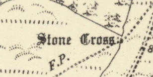
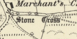
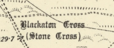
Six small crops from Ordnance Survey sheets in a row, each a place name engraved in a heavy angular blackletter hand
The name Stone Cross engraved in a heavy blackletter hand on a six-inch sheet A second engraving of the name Stone Cross in the same blackletter hand The name Blackaton Cross, with Stone Cross beneath it, in the same blackletter hand
Top, six names in the Old English face: Tumuli, Tumulus, Tumuli, Tumulus, Tumulus (beside two roman capitals from a neighbouring label), Fort. Below, three in German Text: Stone Cross twice, Blackaton Cross. A tumulus is a burial mound. OS six-inch 1st ed. · © National Library of Scotland.
A photographic copy of a printed page of 1921 setting out three classes of antiquity, with the words Old English characters and German text each printed in their own blackletter face
O. G. S. Crawford of the Ordnance Survey set the three classes out in words in 1921, with Saxon moved out of the Old English face since 1881. Crawford, Notes on Archaeology for Guidance in the Field, 1921.
03Provenance

How the archaeology got onto the map.

1840s to 1890s

The survey

  1. 01

    The field examiner

    A field examiner walked the parish on foot. He asked the people who lived there what each place was called and who owned it: the landowner, the parson, the schoolmaster.

  2. 02

    The Object Name Book

    The names went into the Object Name Book: one ledger line for each name and the person it came from. England’s Name Books were mostly destroyed by bombing in 1940; Cumberland, Westmorland, Northumberland, Durham, part of Hampshire and Scotland survive.

  3. 03

    The instruction, and the change

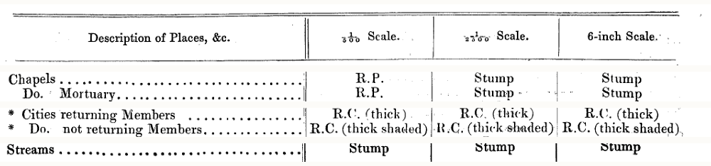
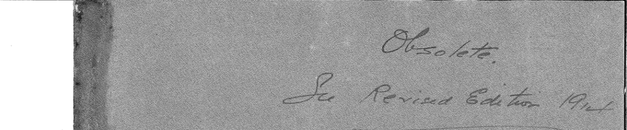
    The circular set a typeface for every other kind of name too. Its abbreviations: E.C. is Egyptian Capitals, R.C. Roman Capitals, and Stump the sloping face set above as Italic. By 1921 Saxon had moved out of the Old English face and in with the medieval, and the Survey wrote Obsolete on the circular’s cover. Waystone reads each sheet by the rule in force when it was engraved.

    Rows of a printed Victorian table: a heading row with three scale columns, then chapels, mortuary chapels, cities returning and not returning members, and streams, each with the Survey's typeface abbreviation in every column
    Four more rows of the 1881 table under its heading: chapels and mortuary chapels, cities returning and not returning members, and streams. OS 404 (1881) · National Library of Scotland Map X3.234.
    The grey cover of the 1881 circular, with two lines written across it by hand in ink
    The cover of the 1881 circular, marked by hand in ink: Obsolete. See Revised Edition 1914. OS 404 (1881) · National Library of Scotland Map X3.234.
  4. 04

    The engraved sheet

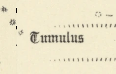
    The name went onto the fair plan, the clean drawing the engraver worked from, and the printed sheet carried it in the face the circular had set.

    The word Tumulus engraved in a blackletter hand on a cream Ordnance Survey sheet
    Tumulus on Devonshire CXII.SE, in Old English: an antiquity the surveyor judged Druidical or Saxon. OS six-inch 1st ed. · © National Library of Scotland.
Today

Waystone

  1. 05

    The heritage registers

    The recorded places are held by the heritage registers: Historic England, Cadw in Wales, Historic Environment Scotland, and the county records. In the 1940s the Survey’s card index of antiquities became the basis of the national archaeological record, so today’s record partly descends from the map.

  2. 06

    The research library

    Waystone’s research library holds 203,888 documents, linked to about 850,000 recorded places.

  3. 07

    The pin

    The pin on Waystone’s map is that place: the register record it comes from, and the documents linked to it.

    Waystone's map pin for a prehistoric place: a gold line drawing of a striding human figure inside a dark disc with a gold rim
    The pin Waystone draws for a prehistoric place.

Both pieces of work are in progress. Nothing in this section is in the app yet.